antiAtlas Journal #01 - 2016
Re-drawing the experience: Art, science and migratory conditions
Sarah Mekdjian and Marie Moreau
Sarah Mekdjian is a lecturer in Geography at the University Grenoble Alpes and PACTE laboratory in Grenoble (France). Her research deals with critical geography, counter-cartography and research-creation projects, dealing mainly with contemporary urban life, migrations and the right of asylum. As a member of the European EUBorderscapes project, she has explored participatory mapping practices in collaboration with asylum seekers and artists. sarah.mekdjian@univ-grenoble-alpes.fr
Marie Moreau works and lives in the Rhône-Alpes region, France. She has a degree from the Ecole Supérieure d’Art de Grenoble. Filmmaker, artist-explorer, her films and art installations are currently presented in France and internationally. Her work is embedded in society. She questions the transmission of forgotten, hidden, excluded experiences. By creating conditions of hospitality, she opens shared places of aesthetic commonality. moromari@no-log.org
Translated by Caroline Mackenzie. Photographs © Mabeye Deme
Keywords: map, migrations, participation, refugees, research-creation.

To quote this article: MEKDJIAN Sarah and MOREAU Marie, "Re-drawing the experience: Art, science and migratory conditions", antiAtlas Journal, 01 | 2016, [Online], published on June 30th, 2016, URL : http://www.antiatlas-journal.net/01-re-drawing-the-experience-art-science-and-migratory-conditions, DOI : http://dx.doi.org/10.23724/AAJ.11, accessed on Date
Introduction
1 The project that we discuss here is entitled Cartographies traverses/Crossing Maps. Started in 2013 in Grenoble France, it developed as a collaborative work by two researchers in geography, three artists, and twelve inhabitants of Grenoble (men and women) who are or have been asylum seekers. We, Sarah Mekdjian –geographer- and Marie Moreau –artist-, will discuss the conditions of our collaboration. When we each speak in our name, it’s mentioned in the text with our initials [SM] for Sarah Mekdjian, [MM] for Marie Moreau.
Our project was inspired by several political, ethical and methodological issues raised by contemporary migration research in the field of social sciences. At a time when qualitative research in social sciences relies heavily on narratives for learning about and analyzing migratory trajectories, these methods can also lead to a replication of violence prompted by administrative procedures involved in applying for asylum. Asylum seekers arriving in countries that have signed the Geneva Convention are continually asked to “tell their story” in a context where trust is impossible and a suspicion of ‘false refugees’ reigns. In France, these stories must be written in French and sent to the Office français de protection des réfugiés et apatrides (OFPRA). For the Department of Isère, France, the Prefecture, located in Grenoble, has authorized an association to re-transcribe and translate these narratives and to enter the fingerprints of asylum seekers in the Eurodac system, these being two mandatory conditions for seeking asylum. Following reception of the narratives, OFPRA summons the asylum seekers for an oral interview during which they are expected to tell a story that matches the original written version and can be verified. The story also needs to correspond to the statutory definition of the refugee in the Geneva Convention. The inclusion of evidence in their file is one of the prerequisites for a successful application for asylum (Fassin, Kobelinsky, 2012). These requirements, which deny the continuous action of memory, the subconscious, and the context in which the narration is reproduced, give rise to a substantial and symbolic violence which re-occurs later in interviews with researchers or other representatives of authority (government agency, political figures, scientific researchers, medical practitioners, artists, etc.). If asylum is refused by OFPRA, applicants can appeal to the Cour nationale du droit d'asile (CNDA). In 2014, OFPRA and CNDA awarded asylum in 22.5% of all applications, in other words, 77.5% were refused.
A critique of “narrative truth“
In a context where government agencies require ‘verifiable’ stories before deciding whether or not to grant asylum, our research/creation project Cartographies traverses/Crossing Maps did not focus on truth or referentiality. Our objective was to challenge the notion of “truth”, as described above, by co-producing maps of migratory experiences: not as stories or testimonies that are true or false, nor as referential material but as referential and non-referential discourses. We invited asylum seekers to work with forms of expression that do not echo the interactions prevailing in governmental agencies. In our discussions, we did not ask questions. Rather than ask participants to “tell their story”, we invited them to draw freehand maps on paper or cloth, without references to maps (avoiding truth or untruth), and without judgment (“well done = badly done = not done”, Filliou, 1968). This work raised issues about how to develop a co-production with people having very different and unequal status (artist, researcher, asylum seeker): we were trying here to revisit these asymmetries and complementarities.
Hand-drawn maps, “well-done=badly done=not done”
In this article, we review our collective experience, its production and dissemination, and the negotiations involved in order to address the aesthetic, political and scientific issues that emerged. This process included, of course, the questions we shared and also the efforts, obstacles and difficulties which generated privileged situations for analysing our working methods.
[SM] I will discuss my experience as researcher with Marie Moreau and the path we created together.
[MM] I will describe my practices and methods for drawing maps, as used with Sarah Mekdjian.
This article will draw, literally and figuratively, the precise lines of complementarity and tension that structured our research-creation project in the context of contemporary migratory policies. We decided to play with the classic format for a research article by creating a text-map and by drawing a map-text, a heuristic cartography. In other words, this approach has allowed us to extend our experimentation in research-creation by re-inventing text-writing and map-drawing. We invite our readers/spectators/visitors to read the map and circulate through the text, or circulate around the map and read the text, using these complementary movements to explore a hypothetical field of research-creation in which specific social and political situations interact.
next...
I. Working in context
a. Places for a research-creation project
2 This text begins by identifying the places where we met and worked. We explain where and how we met in 2012 and how we started working together.
next...
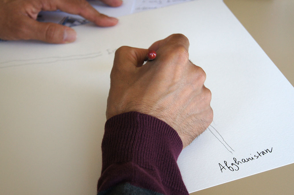
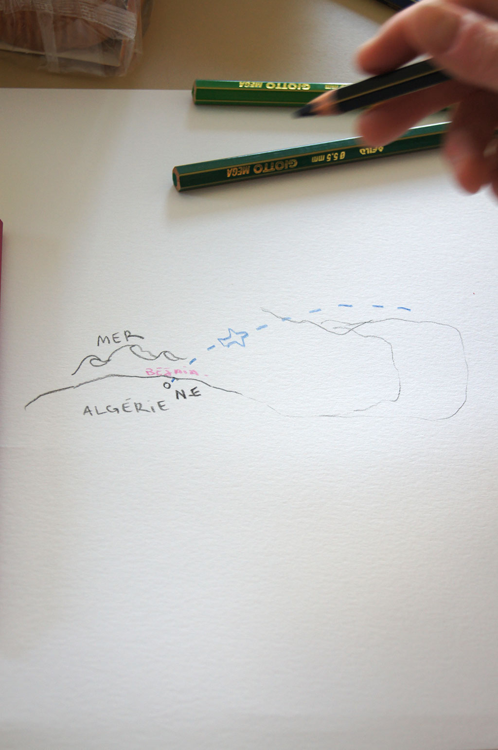
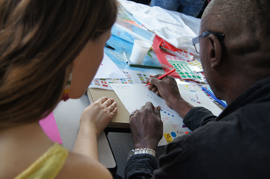
Fig. 1: Places and objects linked to our meetings and participatory mapping workshops, 2013
b. Meetings of artists, researchers
and asylum seekers in Grenoble (France)
3[SM] In 2012, Marie Moreau worked in several social centres in Grenoble including Point d’Eau, “a haven of life for world of survival” where people can relax, do their washing, have a coffee, and at Fournil, an association with a day centre offering shared meals. Some of the people attending these social centres were asylum seekers. She invited visitors at these two centres to draw maps using black felt pens on large white tablecloths:
I remember Vassili, whom I had already met in my neighbourhood. One morning, he was at Point d’Eau. I sat next to him. Every time I went there, I set out cloths, pens, cottons, and some hand-drawn maps … I had a small tablecloth and my felt pen. Vassili was making a catapult with a rubber; he needed help. I gave him a hand and then I drew this very beautiful object. Then, he helped me to draw his territory, his landscape (Houbey, Moreau, 2012).
Avoiding institutional artistic spaces, Marie’s practices “are created in context, in the territories themselves, by closely interacting with places and people” (Nicolas-Le Strat, 2015). Her project, ATLAS LOCAL, was launched at Fournil and Point d’Eau, together with another project proposed by Lauriane Houbey (artist and choreographer) in 2012, La maraude cartographique. These two projects were brought together under a single theme Géographies intérieures/Interior Geographies. This is how Marie describes her work:
In the beginning, I wanted to produce artistic pieces linked to meeting places – both sanitary and social – that have a history and activities that I can relate to. What is precious for me is that people let me try. Visitors, diners, volunteers, employees: they watch me as I set out my space and time. Sometimes a few take an interest in what I’m doing, sometimes it’s me who looks at what they are doing or what is being made there. In any event, it is a way of escaping (Houbey, Moreau, 2012).
I met Marie Moreau and Lauriane Houbley at the Géographies intérieures exhibition. I first visited their exhibition with students from the University of Grenoble where I teach, and later I returned on my own. After the exhibition which had displayed the ways we see and experiment with relational, narrative, and sensitive maps, I suggested that we set up another residential workshop with these artists, this time in the offices of Accueil Demandeurs d’Asile (ADA) at the Maison des Associations. ADA is an association which helps asylum seekers prepare their applications and, in particular, their appeals to CNDA. With ADA’s employees and volunteers, some of whom are lawyers, the applicants develop, edit and translate their narratives into French. Setting up a cartographic workshop in a place where people are usually working on their applications to government agencies was a way to try in part to displace these activites.
In May and June 2013, we – Marie Moreau, Lauriane Houbey and Fabien Fischer, (artists), Anne-Laure Amilhat Szary and myself (geographers), Mabeye Deme (photographer), Coralie Guillemin (research assistant) – organized map-drawing workshops twice a week in ADA’s offices. We invited people we had met at ADA to participate. Twelve Grenoble residents, at varying stages in their preparation of an application for asylum, contributed regularly to these workshops. They came from Armenia, the Democratic Republic of Congo, Guinea, Azerbaijan, Sudan, Eritrea, Afghanistan and Algeria.
next...
II. Why cartography?
a. The map, a meeting place, a relational tool
4 The gestures we used for drawing maps created a triangular relationship – involving the maps, the organizers of the workshops and the participants – that is quite different from the relationship during interviews with government officers but also with researchers (Mekdjian et al., 2014; Mekdjian, 2016). We suggested to the participants that they draw maps of exilic experiences. As the geographer Denis Martouzet has suggested (Martouzet et al., 2012), maps appear to be a ‘transitional object’, a notion borrowed from Winnicott’s psychanalysis. Denis Martouzet explains that mapping allows to avoid some of the limitations on life narratives, in particular the process of ensuring “narrative consistency” during its re-transcription. The passage from gesture (drawing) to object (map), in a joint initiative by participants and researchers, implies other forms of interactions and narrativity:
a less demanding involvement by the researcher and the interviewee, while giving the latter the freedom to continue their association of representations, without having to build or reconstruct, at the same time, their defence arguments while remaining coherent for themselves (Martouzet et al., 2010 : 168).
Using maps and cartography as relational tools and studying how map-making, geography and contemporary art can be linked together are contributing to a critique of cartography’s scientism (defined by objectivity, realism, and truth). The history of map-making and the way it is used (Harley, 2002; Wood, 1992; Tiberghien, 2010), remind us how:
all history of science begins as history of art. [ …] From this perspective, there is only one history, which is shared by art and science: let us say, the history of representations in the broadest sense” (Latour, 2012: 91).
The uses and re-inventions of cartography by contemporary artists are contributing in part to the epistemological redefinitions of scientific mapping. The map is a central figure in the spatial turn of contemporary art (Volvey, 2007; Harmon, 2010; Tiberghien, 2010; Imhoff, Quiros, 2014). Gilles A. Tiberghien has shown that several contemporary artists use maps as an “instrument for rupture, critical modality in the field of representation” (Tiberghien, 2010: 198). Following the writings of Lucy R. Lippard (1983), he identifies two artistic movements in particular for which the map has emerged as an object and as a practice for critique: conceptual art in the 1960s, and land art in the 1960s and 1970s (Volvey, 2003, 2007, 2010).
Thus, in contemporary art and social sciences, and more specifically geography, the map has gone through a crisis of legitimacy, as a tool that should represent space, from an objective zenithal and ‘overarching’ viewpoint (De Certeau, 1990, t.2: 141). There are many contemporary artistic cartographers who “subvert geography as a discipline of knowledge that disciplines space” (Imhoff, Quiros, 2014), similarly to research and militant attempts to produce counter-maps, post- and de-colonial maps, and critiques of methodological and political nationalism (Crampton, 2006). Cartography, which has been used to conquer, discipline and monitor, is used increasingly to challenge spatial power structures and to introduce breaches (Bailly, Gould, 1995; Harley, 2002). As a tool for consolidating modern conceptions of the Nation-State (notably, by creating the concept of a border line), the map serves as much as a tool for surveillance and traceability as a technology that allows exiles to move around (principally through GPS apps on mobile telephones). In the exhibitions organized by the antiAtlas of Borders collective, there were artworks that demonstrated how maps and geo-digital surveillance instruments have been diverted from their military purpose in order to meet critical, aesthetic and political objectives.
Subverting the formal codes, normative horizons of truth and legitimate knowledge for maps is in fact an attempt to transform the way we imagine migration and borders
Subverting the formal codes, normative horizons of truth and legitimate knowledge for maps is in fact an attempt to transform the way we imagine migration and borders, to challenge national and fixist representations of migratory experiences, to explore the blind spots of contemporary systems of migration controls.
next...
b. Mapping practices
5 During the cartographic workshops in Grenoble, we used several practices for research and map creation.
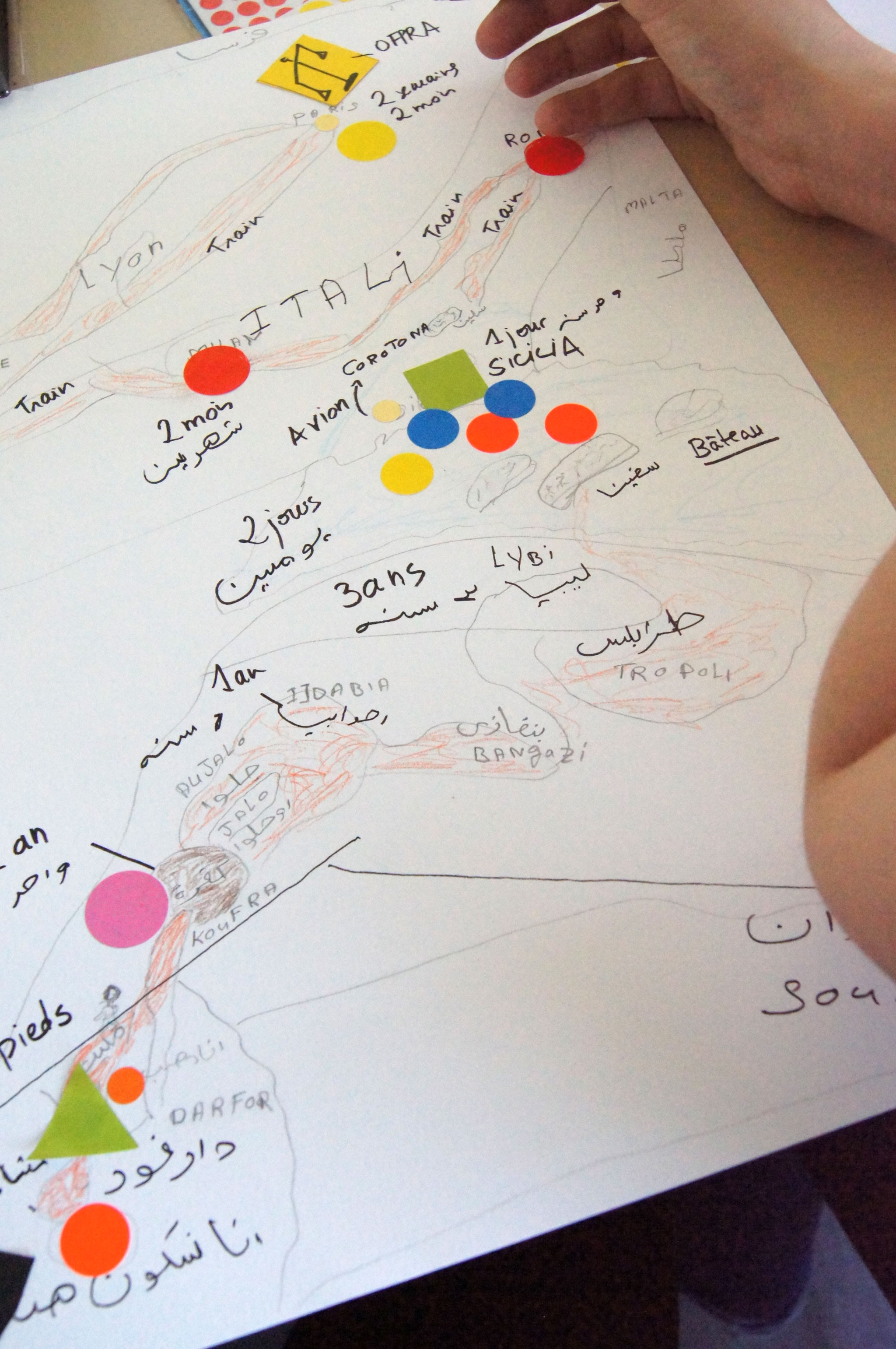
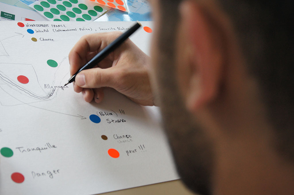
[SM] First, I worked with the participants on a map key/legend and a collection of hand-drawn maps entitled Légendes du voyage. The map key is composed of words selected and used by participants to describe contemporary migratory experiences. These words were symbolized by stickers of various shapes and colours. This allowed for participants to share memories, stories, discourses while also contributing to a collective and visual symbolization on contemporary conditions of migration (see Figure 2).
[MM] Next, I suggested that we make subjective maps as an extension of the ATLAS LOCAL project started in 2012. The participants in the workshops draw maps on large pieces of white linen and cotton (see Figures 3 and 4). After the workshop, I embroidered some of the maps. I then juggled with and rearranged the reinterpreted and embroidered subjective maps.
Mapping, as performed by the artists, researchers and participants, not only provided a structure for our relationship, but also became the object of exhibitions, an aesthetic form, and a field of research.
Meanwhile, Lauriane Houbey and Fabien Fischer developed two sound pieces, D’ici là le milieu and Ici pas encore respectively, which include discussions with the participants about their maps, close to a visual elicitation process. Les légendes du voyage, ATLAS LOCAL, D’ici là le milieu and Ici pas encore, are all part of the overall Cartographies traverses/Crossing Maps project. Mapping, as performed by the artists, researchers and participants, not only provided a structure for our relationship, but also became the object of exhibitions, an aesthetic form, and a field of research. The maps produced allowed the participants to tell fragments of their memories, reminding us that “life [is] itself a weaving of stories told” (Ricœur, 1985: 356).
next...
c. ATLAS LOCAL, an evolutive mapping project
6 [MM] As a contribution to this text, I suggest a number of quotations and of thoughts.
Walking along a path. Updating a network of presence without for all that producing a land register, or blocking relationships, or searching to pin down some indiscernible identity. But showing how reference points operate and allow you to become a part of changing events. Maps are not instruments for observation. They are instruments for evacuation. Fernand Deligny (1975)
We can guess at the experiences emerging from these drawings, they interact with our representations of the world and with political transformations that the drawers express.
Every map expresses an aim, a movement; for some, it is a way to occupy territory, for others, to not lose oneself, or to remember. We can guess at the experiences emerging from these drawings, they interact with our representations of the world and with political transformations that the drawers express. ATLAS LOCAL is an evolutive project. Initiated in 2012, at the suggestion of my sister, a social worker, it has been transformed into Cartographies Traverses/Crossing Maps. My sister knew of my interest in subjective and cognitive mapping. She often told me about the stories she heard from visitors at Le Fournil where she works. One day, she told me that the hosts had found a new use for table mats, drawing maps. When they sat down for lunch, some of them would push aside their plates and made drawings with their view of geography, the geography of their journey on the earth’s surface and through the labyrinth of French government agencies. She told me about these maps in which towns recently mentioned in the news and places such as the Médecins du monde centre, hospitals, post offices, stations were muddled together. I went to the canteen to see the maps, but they had been thrown away after the meal. I was haunted by these imaginary maps. I told myself that they represent the trace of a silent, discreet presence, in the hope of finding a way and a place. I returned to this social centre and later to another, I laid out cotton and linen cloths on the tables. I had some black pens and I waited to see who I would meet.
ATLAS LOCAL is a gathering, a collection, to which I bring maps. I place them according to the environment and the situation. For this article, I selected two subjective maps by travellers, which I describe here:
Oslo mon amour is a fresco: a journey through space and time, with specific phases, some sections missing, a journey back with no obvious explanation, and a ‘here’ that cannot be represented.
Shamil ou le monde poisson presents a world in aggregate, with zones known, remembered or positioned around the place where someone is telling the story. By chance, the drawer sketched a sort of fish which takes in Eastern Europe, Northern Europe, Ukraine, Russia and even Iran, back to front. The world has been turned upside down along its north-south axis. East is in the west and vice versa. It’s like looking in a mirror, a reversed reflection.
“It is not a period of unfinished works, it is a period of fragments” (Marcel Duchamp)
Re-inventing the perspective,
RELATIONAL MAPS
ATLAS LOCAL is a collection of subjective maps drawn by travellers, non-travellers, drifters, dreamers. Drawing begins, leading to a conversation about trajectories, around a table, a white cotton and linen tablecloth serving as a blank page. Drawn and then embroidered, they include landscapes, territories more or less known, recognized, interior geographies. Brought together in the shape of an evolutive installation, the maps become a collection, a local atlas.
If the map is different from the sketch, it is because it is totally turned towards an experiment within the real. It does not reproduce an unconsciousness closed in on itself, it constructs that unconsciousness. […] The map is not drawn onto something that one prepares as a finished whole; it can be challenged in all its dimensions, deconstructed, reversible, constantly open to modifications. It can be torn up, changed, adapted to different interpretations, reorganized by an individual, a group, a social programme. We can draw it on a wall, see it as a work of art, or build into as a political action or as a meditation. Gilles Deleuze, Félix Guattari, (1980: 20).
next...
III.
Proposing Another Way Of Distributing The Sensible
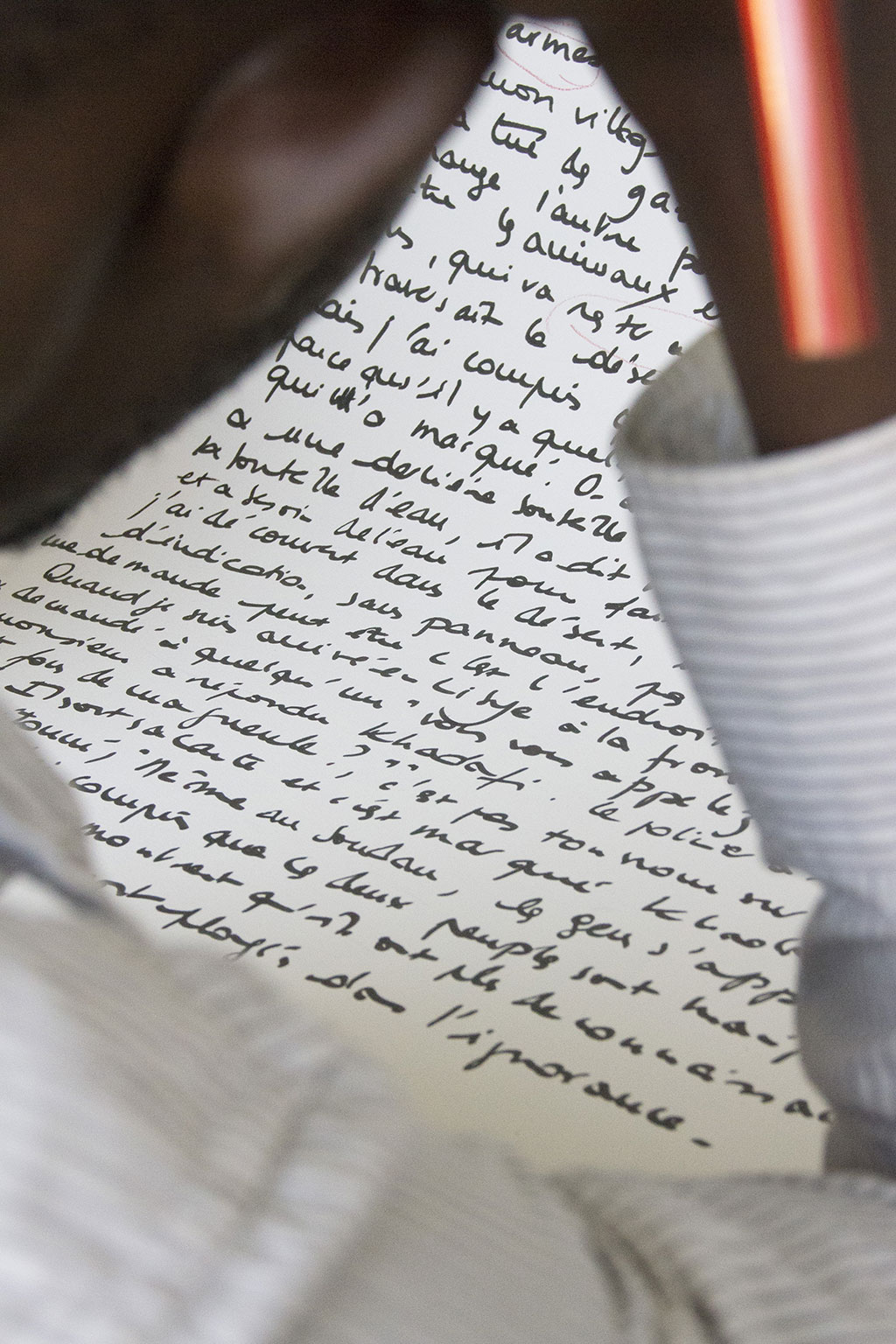
7 [SM] The maps created in Grenoble are hand-drawn on a white background; they are made up to hesitant, sometimes scratched-out lines; the roads fork, stop, begin again. Les légendes du voyage mention danger, luck, love, hunger, thirst, fear, police, and injustice. As an interaction with the public, Cartographies Traverses/Crossing Maps provides a “cartographic experience”, which is ’estranged’, it displaces our usual references when reading maps and our interpretative indications of migration.
With regard to maps of trans-Saharan migrations, especially those appearing in the media, the geographers Armelle Choplin and Olivier Pliez have shown that these display “an image of a fluid migratory space, i.e. where a continuous line indicating several migratory routes hides all the “rough edges” – spatial/temporal, political, police, monetary – which serve as markers along the routes taken by migrants” (Choplin, Pliez, 2014). Quite apart from the technical difficulties of representing and analyzing sensitive and individual data, one can also put forward the hypothesis that over-representation of these route maps, is also influenced by political choices.
Migrant routes and flows are often displayed vaguely with arrows and, on some maps, become confused when reproduced in the media and this feeds fears of invasion:
The long lines that trace African migration towards Europe reinforce the somewhat worrying image of an invasion advancing along several routes (Ceuta and Melilla, Libya, etc.) that are rarely taken by thousands of migrants simultaneously. These maps make us forget that these flows are marginal for most African, and even for trans-Saharan, migration. They create confusion between ‘routes’ and ‘flows’ (ibid.).
In Cartographies Traverses/Crossing Maps, some maps offer drawings that contain images of space from above and at ground level. These forms of projection are not obvious; they were constructed step by step in a series of mapping gestures. They shift the focus in the way maps are made and in the way we read them. Often a person will draw several series of maps, each from a different perspective, a new projection, influenced by memories (see Figures 5 and 6). Our eyes drift and need time to understand the sense, follow a line, or find a reference point.
The maps are hand-drawn; they are made of lines, blanks, silences, breaks, changes in scale, forks, and hesitations.
Maps express not only space, but also time. Because we also see the corrections, silences, breaks, changes in scale, forks, and hesitations. All this bears witness to the movement of memory. How do we re-trace a posteriori the path we have already taken, the migratory journey that took ten years or two months? Do you start at the river Ubangi in RDC or the Malherbe bus stop in Grenoble? Cartographies traverses/Crossing Maps is an invitation to read maps, and to feel lost for a while. The project “emerged from the interaction of multiple decisions, skills, contributions, and interpretations” (Nicolas-Le Strat, 2015). To understand this collective and co-constructed work, we decided to include our list of co-authors.
next...
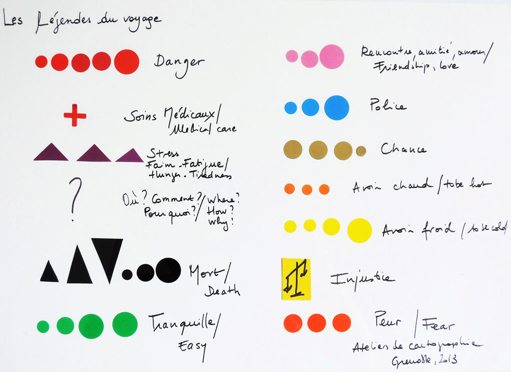
Fig. 2 Légendes de voyages. Collective production, map-making workshops, Grenoble, 2013.
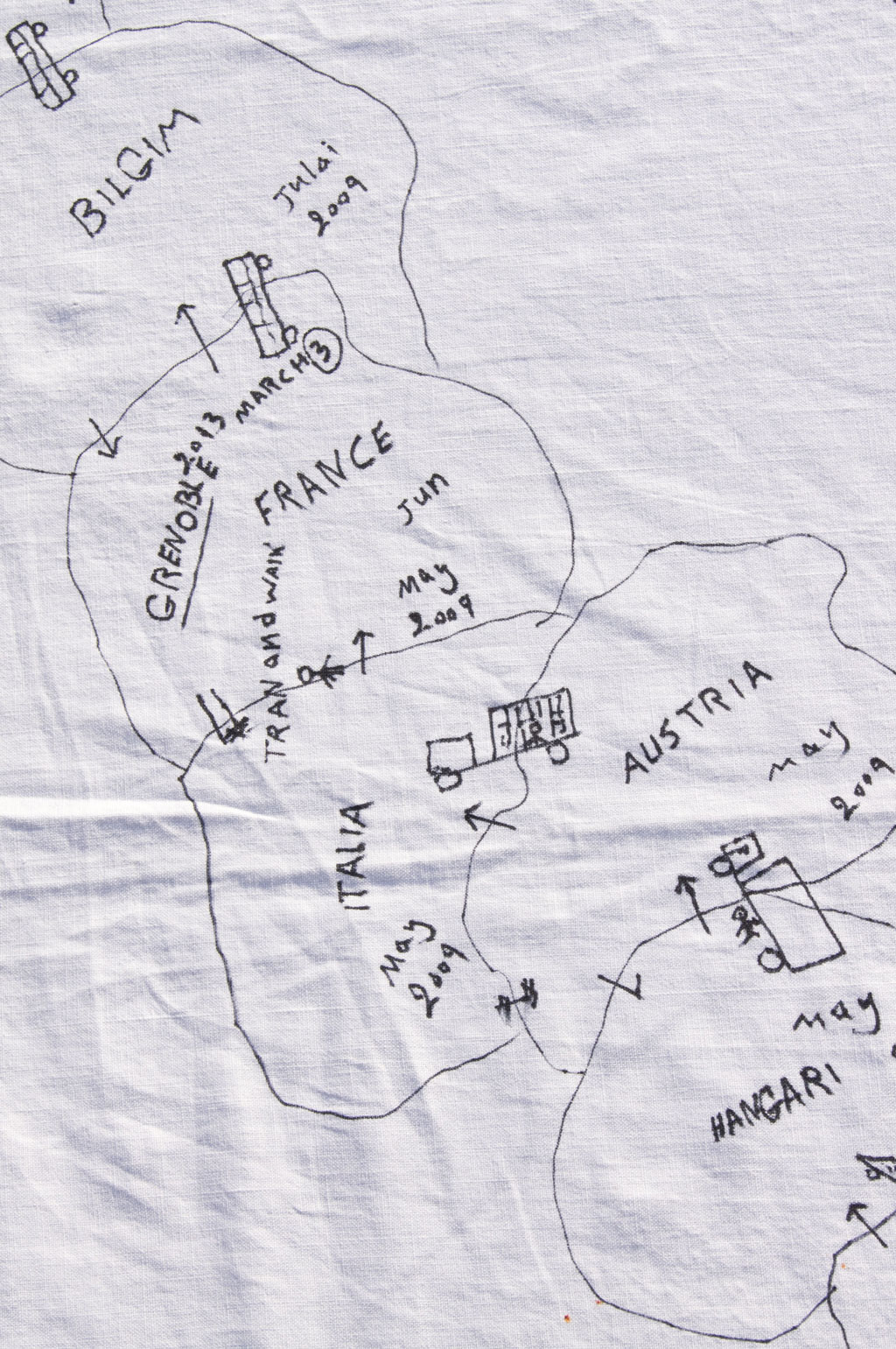
Fig. 3 Fragment from ATLAS LOCAL, H.S., Marie Moreau,
map-making workshops, Grenoble, 2013, felt tip on cloth.
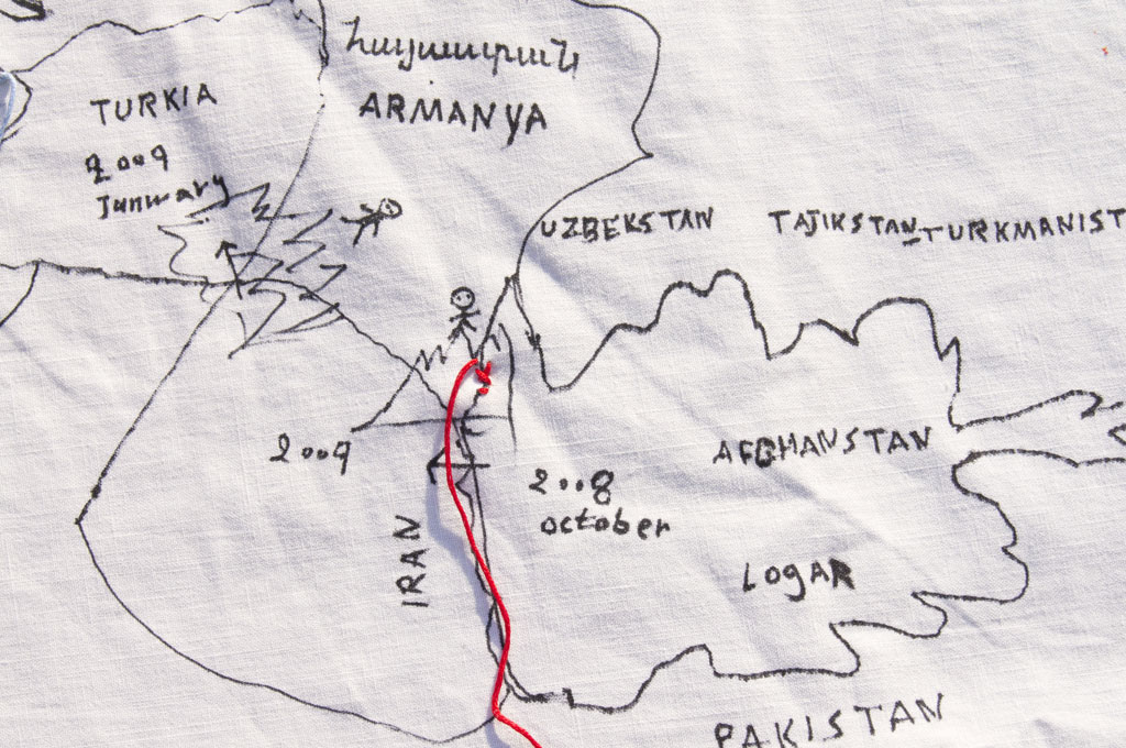
Fig. 4 Fragment of ATLAS LOCAL, H.S.,
Marie Moreau, map-making workshops, Grenoble, 2013, felt pen on cloth and cotton thread.
Fig. 5 Du Soudan en France (1), Issa Ibrahim Hamid, map-making workshops, Grenoble, 2013
IV. Participation And Co-Authorship. Issues In Shared Art And Unequal Statuses
a. Co-authorship in participatory mapping workshops
8 Laetitia ABBAS
Augustin ABBAS
Alishum AHMEDIN
Ahmedin
Anne-Laure AMILHAT SZARY
Shamil ASTAHANOV
Fanny BRAUD
Mabeye DEME
Alpha DIALO
Fabien FISCHER
Karine GATELIER
Nasruddin GLADEEMA
Coralie GUILLEMIN
Lauriane HOUBEY
Karim HUSEYNOV
Issa IBRAHIM HAMID
Ilhem
Jacqueline LEININGER
Fiston MASSAMBA
Sarah MEKDJIAN
Tatevik MELKONYAN épouse MNATSAKANYAN
Marie MOREAU
Salomon PALUKU
H. S.
Aboubakar SOULEIMAN GUELLEH
Olivier TIRARD-COLLET
Kanké TOUNKARA
next...
b. Why this co-authorship list? Working conditions for the project and unexpected outcomes
9 [MM] For me, co-authorship means sharing, or rather pooling, as part of a relationship. In this specific case of an aesthetic quest that we carried out on wandering and map-making, our objective was to arrive at making “a return trip along a trajectory”. In this way, we confront the fragility of vague itineraries and the vulnerability of lost markers. The maps drawn by people I met were multiple and varied. Each map, each participant, each protagonist drew a fragment of our world, of their world. Because the situation and the relationship allows it. This is what I mean when I talk about relational art: artwork in which the process of creating allows, because of the relationship, the emergence of a word, a line, a movement.
How to present the conditions of co-creation and co-authorship of the project?
The conditions necessary for co-authorship bring us closer to the research carried out by Pascal Nicolas Le Strat on cooperation and co-creation:
Fundamentally, the process of cooperation itself becomes the ‘author’ of the work. Artistic practice is achieved therefore through an activity-network which brings together multiple intermediaries (methods, knowledge, skills, devices, shapes and languages) and numerous contributors, all of which work together on the project. The artist is no longer at the centre because the network-dynamic renounces the very idea of centrality and periphery. The positions are permanently reversible. At a certain point, it is the artist’s initial intention that makes the difference and attracts attention and energies, but it comes necessarily at the moment when the event takes place, when an unexpected initiative, a word out of place, a perturbing interaction significantly influences, has a long-term impact and ends up reorienting the process. Nevertheless, the role of the artist does not disappear. Indeed I think that the quality is enhanced, since it becomes more relative, more risky, more exposed. The artist works more effectively by being part of the situation. No longer at the centre of the situation, but within it. (Nicolas-Le Strat, 2015).
[SM] How to present the conditions of co-creation and co-authorship of the project? Our work seeks to avoid the atomization of individual stories, generated by the procedures for obtaining asylum. The key is to circumvent the hyper-individualization of the procedures which, in part, prevent the emergence of shared discourses and claims. The list of co-authors reflects the ethics of a collective participation.
Participation is a general term that includes a wide range of epistemologies and methodologies. We could say that participation means, at the very least, to “make with” or, in other words, to conceive “relational situations […] as a source of knowledge” (Volvey, 2014). The conditions in which relationships develop are central (Bondi et al., 2002). For Anne Volvey, one condition of all participative and relational approaches is that “the experience must be fully thought through, using the principle of symmetry” (ibid.). As Dominique Paturel explains about the notion of ‘participative research’, it is often “an ethic of ‘care’ as a way to bringing together moral conceptions and research practices with a background of sensitivity and ordinary life” (Paturel, 2013). How do we interpret ‘participate’ and ‘being a participant’ during the workshops and, later, in the exhibitions? The list of co-authors gives the names of all those who ‘participated’, superimposing the status of ‘participants’ or that of ‘authors’. Are they equivalent, do we need to disconnect them and identify the different types of – changing and evolving – relationships involved? The notion of ‘author’ refers to the field of the copyright laws. It implies specific rights including moral and economic rights, whereas ‘participant’ is not a legal status.
[SM] Not every decision was taken collectively. Several decisions were taken by the researchers and artists, without necessarily discussing them with the participants like opting for bi-weekly meetings at fixed times at the ADA centre. The decision to develop the main themes of migratory experiences and life in Grenoble was discussed by everyone; we worked for a long time, in French, English and in other languages, in particular Arabic, to produce a list of words that were meaningful for everyone in discussing experiences of displacement, border crossings, and exile. At this point, I suggested that we develop a collective map legend using symbols of different shapes and colours to symbolize the key words; our collective discussions then focused on the choice of colours and shapes. Marie Moreau proposed that we use a single format: drawings using black felt pens on white cotton and linen clothes.
next...
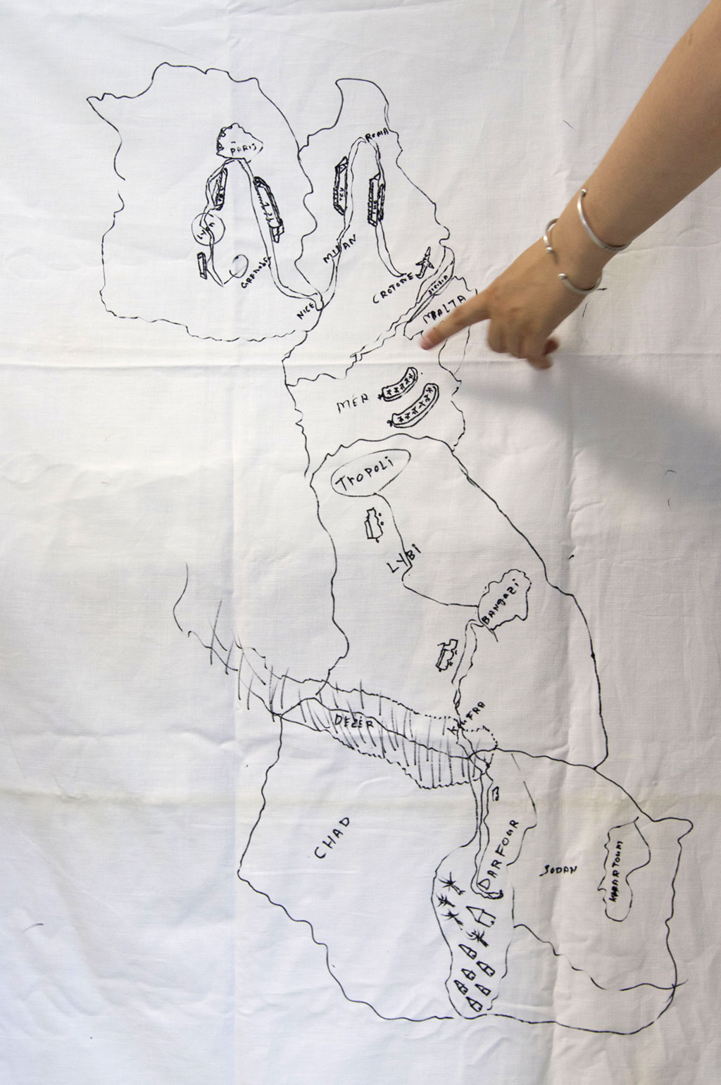
Fig. 6 Du Soudan en France (2), Issa Ibrahim Hamid, cartography workshops, Grenoble, 2013
10 The participants/authors then decided on a certain number of other elements, for example the creation of a 3-D map (using clay and wood) and other reinterpretations of the artists and researchers’ intentions. Some participants/authors suggested that the first exhibition of Cartogaphies Traverses/Crossing Maps should open on World Refugee Day (20 June 2013) in Grenoble together with a concert by a group of musicians playing music from Sudan.
Thus, not all decisions were taken collectively. However, the participants reacted, positively or negatively to our proposals and in some cases suggested changes and new creations. Pascal Nicolas-Le Strat has analysed this question of ‘co-creations’:
Sometimes, the artist takes the initiative, sometimes she/he allows himself to be guided by proposals over which she/he has little control, or indeed any real understanding. This shift in positions is essential. Reversibility is fundamental; it forces everyone to be available to others, rethink their objectives, re-assess their desires and intentions. The artist places herself/himself in the middle. She/he acts as a mediator for the various interactions. She/he is therefore not dispossessed of her/his capacity to operate – she/he is not dispossessed, though she/he is often relieved from her/his function – but she/he becomes involved differently, in a less assured, less interventionist, less arrogant, way. The shared work deeply transforms her/his expectations and aspirations for her/his activity (Nicolas-Le Strat, 2015).
The question of participation must also necessarily be understood in terms of the material and economic conditions for carrying out the project. These economic conditions link the question of participation to the legal questions of authorship, employment rights and copyrights. Our workshops were based on asymmetric economic relationships, an aspect that we had not fully thought through.
The participants were invited to contribute as volunteers, because, as asylum seekers, they would not have the right to work, whereas the researchers received their salaries and the artists their fees from a CNRS (Centre National de la Recherche Scientifique) grant for the time they spent in the workshops. We could have discussed the question of paid employment jobs for the refugees (who are allowed to work), but we did not. Such an “unthought” has forced me to think about the economic conditions of participation and the recognition of collective and individual work.
The question of participation must also necessarily be understood in terms of the material and economic conditions for carrying out the project. These economic conditions link the question of participation to the legal questions of authorship, employment rights and copyrights.
To subvert the impossibility of remunerating asylum seekers, whose status prevents them from working, the status of ‘author’, as defined by the law on Intellectual Property, made it possible to ensure a legal and financial recognition of each person’s participation and work.
But, how do we define authorship of an art work that has been produced collectively and individually at the instigation of researchers and artists? What do ‘authoring’, ‘working’, ’participating’ mean, individually and collectively, in this project?
These discussions about the questions of status, authorship, participation and recognition continue today.
next...
V. Conclusion : Re-drawing the experience
11 This paper focused on describing the relationships between researcher, artist, asylum seekers and refugees in the context of a co-authored research-creation project. To address the ways we worked, we resorted once again to drawing a map. Re-drawing the experience (see Figure 7) was prepared for this issue of antiAtlas Journal. The map reviews our objectives and intentions and covers several aspects of our relationships, using the visual and spatial arrangements of meaningful words that emerged from our discussions. We have attempted to analyse our methods in working together by practising them once more. We met many times to draw and redraw the paths we had taken together: our meeting, the opening of the workshops, the mapping practices we developed, the role each of us would assume, and the timing of the exhibition and the publication. The lines we drew recall the history and the memories of our shared work.
We took an interest in the map, not as an instrument of knowledge, but as a tactical tool used daily by asylum seekers for making connections, exchanging advice, remembering places left behind or transited.
Cartographies are the foundation stone for our relationship: they sparked our interest as artist and as researcher, and also as practices used by the people we met in Grenoble. We took an interest in the map, not as an instrument of knowledge, but as a tactical tool used daily by asylum seekers for making connections, exchanging advice, remembering places left behind or transited. Re-drawing the experience is not a tactical map for survival in Grenoble, nor a souvenir of crossing a sea or desert: it is a map which allows us to remember, it serves as a transitional object and we use it to tell the story of the workshops.
In the map we drew for this article, in addition to the crossing-outs and blank areas which indicate areas of conflict and of unforeseen issues in our work.
The iconographic dimensions of the map, defined by Denis Cosgrove as ’iconotext’ (Cosgrove, 2001 148), allows us to explore textual and visual expressions. Through the map, the workshops and the production of this article, we have sought to bear witness to “more-than-textual, multi-sensual worlds” (Lorimer, 2005: 83). In the map we drew for this article, in addition to the crossing-outs and blank areas which indicate areas of conflict and of unforeseen issues in our work, we have developed a legend that allowed us to see and read the principal issues that we have faced.
Captions for Re-drawing the experience (see Figure 7):
-grey buildings are the institutions and associations around which the asylum seekers’ daily lives revolve (OFPRA, CNDA, Prefecture, CHRS, 115, Médecins du Monde, etc.);
- blue is for the creative devices used during workshops (trajectory, drawing, maps, Les Légendes du voyage, ATLAS LOCAL, etc.);
- yellow for the materials and gestures with which we worked (labels, clay, embroidery, etc.);
-in light brown, the ethical and deontological issues in our relationship (invitation, neither true nor false stories, hospitality, etc.);
-in pink, the practices re-enacted from our artistic and geographical backgrounds (interpreting, representing, remembering, revisiting, retracing, etc.);
- dark brown is for the places, institutions, collectives where the maps were disseminated (universities, Refugees Day, geography magazines, antiAtlas, etc.);
- in green, methods of diffusion and accreditation of our production in terms of science and art (publications, articles, exhibition, artworks);
- and, finally, we included the full names of all partners in the list of co-authors.
Re-drawing the experience is a “disparate whole [that] expresses thought: here, the emergence of an idea; there, an attempt to calm one’s anxiety; here, the extraction of something tangible from confusion; there, the blind desire to make the map merge into the finality of the figure” (Caraës, Marchand-Zanartu, 2011: 9). Scribbe-draw a map-disentangle-tangle-trace, tools and gestures of geographers, tools and gestures of the artist-explorer.
This new creation of a map echoes the gestures we shared with the people we met and worked with in Grenoble. The main function of these structures for sharing, for linking art and science, was to open up a welcoming space where people could express their situation, where ‘truth’ and ‘falsity’ have no place and cannot exclude or silence. Despite our intentions, the financial and legal arrangements required for the workshops have taught us much about the ethical and moral non-conceptions and uncertainties and will remain with us as we continue our projects.
References...
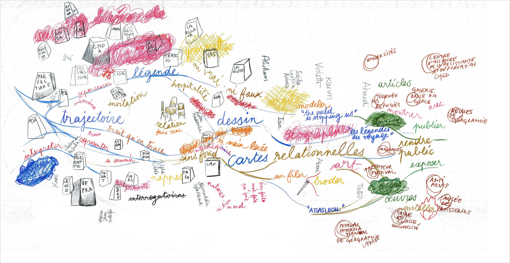
Fig. 7 Re-drawing the experience. Heuristic map-making. Marie Moreau, Sarah Mekdjian, 2015
Bibliography
12 Bailly, Antoine and Gould, Peter, 1995, Le pouvoir des cartes. Brian Harley et la cartographie, Paris, Economica.
Bondi, Liz, (ed.), 2002, Subjectivities, knowledges, and feminist geographies. The Subjects and Ethics of Social Research, Oxford, Rowman and Littlefield Publishers.
Caraës, Marie-Haude and Marchand-Zanartu, Nicolas, 2011, Images de pensée, Paris, Réunions des Musées Nationaux.
Certeau, Michel de, 1990, L’Invention du quotidien. Tome 2 (Habiter, cuisiner), Paris, Gallimard.
Choplin, Armelle et Pliez, Olivier, 2011, « De la difficulté de cartographier l’espace saharo-sahélien », Mappemonde, [En ligne] 103, consulted 14 March 2016. URL : http://mappemonde.mgm.fr/num31/intro/intro2.html
Cosgrove, Denis, 2001, Apollo's Eye: A Cartographic Genealogy of the Earth in the Western Imagination, Baltimore, The Johns Hopkins University Press.
Crampton, Jeremy and Krygier, John, 2006, « An introduction to Critical Cartography », ACME-An International E-Journal for Critical Geographies, [En ligne] 4 (1), p. 11-33, consulted 14 March 2016. URL : http://acme-journal.org/index.php/acme/article/view/723
Deleuze, Gilles and Guattari, Felix, 1980, Mille Plateaux, Paris, Les Editions de Minuit.
Deligny, Fernand and Isaac, Fernand, 1975, « Dérives », Cahiers de l’immuable 20, Republished in Deligny, Fernand, 2007, Œuvres, Paris, L’Arachnéen.
Fassin, Didier and Kobelinsky, Carolina, 2012, « Comment on juge l'asile. L'institution comme agent moral », Revue française de sociologie 53 (4), p. 657-688.
Filliou, Robert, 1968, Principe d’Equivalence : bien fait, mal fait, pas fait, Œuvre, Paris, Centre Georges Pompidou, Collection du musée, [En ligne], placed online in April 2012, consulted 14 March 2016. URL : http://mediation.centrepompidou.fr/education/ressources/ENS-filliou
Harmon, Katharine, 2010, The Map as Art, Princeton, Princeton Architectural Press.
Harley, Brian, 2002, The New Nature of Maps. Essay in the History of Cartography, Baltimore, London, The John Hopkins University Press.
Houbey, Lauriane and Moreau, Marie, 2012, Géographies intérieures, Document d’artistes, [Online], consulted 14 March 2016. URL : http://www.journee-art-contemporain.com/wp-content/uploads/2012/09/Dossier_presentation_Laa.pdf
Imhoff, Aliocha and Quiros, Kantuta (dir.), 2014, Géoesthétique, Paris, B42.
Lippard, Lucy R., 1983, Overlay. Contemporary Art and the Art of Prehistory, New York, Pantheon Book.
Lorimer, Hayden, 2005, « Cultural geography: the busyness of being “more-than” representational », Progress in Human Geography 29 (1), p. 83-94.
Mekdjian, Sarah, Amilhat Szary, Anne-Laure, Moreau, Marie, Nasruddin, Gladeema, Deme,
Mabeye, Houbey, Lauriane and Guillemin, Coralie, 2014, « Figurer les entre-deux migratoires. Pratiques cartographiques expérimentales entre chercheurs, artistes et voyageurs », Carnets de Géographes [Online] 7, consulted 14 March 2016. URL : http://www.carnetsdegeographes.org/carnets_terrain/terrain_07_01_Mekdjian.php
Mekdjian, Sarah, 2016, « Les récits migratoires sont-ils encore possibles dans le domaine des Refugee Studies ? Expérimentation de cartographies créatives », ACME-An International E-Journal for Critical Geographies, [Online], 15, 1, http://ojs.unbc.ca/index.php/acme/article/view/1211
Nicolas-Le Strat, Pascal, 2015, « Une politique de la co-création », [Online], Published August 4th, 2015, consulted 14 March 2016. URL : http://blog.le-commun.fr/?p=873
November, Valérie, Camacho-Hübner, Eduardo and Latour, Bruno, 2010, « Entering a risky territory: space in the age of digital navigation », Environment and Planning D: Society and Space 28(4), p. 581-599.
Paturel, Dominique, 2013, « La recherche participative », [En ligne], consulted March 14th, 2016, published 11 May 2013. URL : http://www.les-seminaires.eu/la-recherche-participative.
Pestre, Elise, 2014, La vie psychique des réfugiés, Paris, Éditions Payot.
Ricœur, Paul, 1985, Temps et Récit III, Paris, Seuil.
Tiberghien, Gilles A., 2010, « Poétique et rhétorique de la carte dans l’art contemporain », L’espace géographique 39 (3), p. 197-210.
Volvey, Anne, 2003, Art et spatialités d’après l’œuvre d’art in situ outdoor de Christo et Jeanne-Claude. Objet textile, objet d’art et œuvre d’art dans l’action artistique et l’expérience esthétique, PhD thesis supervised by Marie-Claire Robic, viva 15 December 2003, Université de Paris 1 – Sorbonne, UFR de Géographie, [Online], consulted 14 March 2016. URL : https://halshs.archives-ouvertes.fr/tel-00804026.
Volvey, Anne, 2007, « Land Arts. Les fabriques spatiales de l’art contemporain », Travaux de l’Institut de Géographie de Reims 129-130, p. 3-25.
Volvey, Anne, 2010, « Spatialités du Land Art à travers l’œuvre de Christo et Jeanne-Claude », in Boissière A., Fabri V., Volvey A. (dir.), Activité artistique et Spatialité, Paris, L’Harmattan, p. 91-134.
Volvey, Anne, 2014, « Entre l’art et la géographie, une question (d’)esthétique », Belgeo 3, [En ligne], consulted 14 March 2016, published 19 December 2014. URL : http://belgeo.revues.org/13258.
Notes...
Notes
13 1. Cartographies Traverses/Crossing Maps is an art and sound production for research/creation, composed of four interlinking elements: Les Légendes du voyage, ATLAS LOCAL, D’ici là le milieu, Ici, pas encore. During the months of May and June 2013 in Grenoble, artists, researchers and twelve participants who were asylum seekers or refugees meeting twice a week for collective workshops. Les Légendes du voyage is the result of an initiative proposed by Sarah Mekdjian, working with Anne-Laure Amilhat Szary and the twelve participants; ATLAS LOCAL was created by Marie Moreau, initiated in 2012 and continued during the workshops; D’ici là le milieu is a sound piece developed during the workshops by Lauriane Houbey; and, Ici là pas encore is a second sound piece created by Fabien Fischer and the participants. Cartographies Traverses/Crossing Maps is a production composed of these 4 facets. At the Centre d’Histoire de la Résistance et de la Déportation in Lyon, two elements (Légendes du voyage and ATLAS LOCAL) were exhibited between 3 February and 29 May 2016.
2. ‘We’ is used here, unless otherwise indicated in the text, to refer the two authors of this article: Sarah Mekdjian and Marie Moreau. Each of ‘us’ will speak in the first person singular in certain sections, indicated by our initials: [SM] for Sarah Mekdjian, [MM] for Marie Moreau.
3. French Office for the Protection of Refugees and Stateless Persons – translator’s note.
4. National Tribunal for the Right to Asylum – translator’s note.
5. See OFPRA’s Annual Report for 2014: https://www.ofpra.gouv.fr/sites/default/files/atoms/files/rapport_dactivite_2014.pdf and CNDA’s Annual Report for 2014: http://www.cnda.fr/content/download/42283/366218/version/2/file/2015-04-29-%20Rapport%20d%27activit%C3%A9%202014%20-%20pour%20mise%20en%20ligne.pdf.
6. http://www.isere-solidaires.org/point-d-eau-havre-de-vie-dans-un-quotidien-de-survie
7. http://www.journee-art-contemporain.com/wp-content/uploads/2012/09/Dossier_presentation_Laa.pdf and http://lexces.net/geographies-interieures/
8. Exhibition held between 13 October and 1 December 2012 in Grenoble at the Laboratoire d’Art Aujourd’hui (http://www.journee-art-contemporain.com/wp-content/uploads/2012/09/Dossier_presentation_Laa.pdf).
9. Gilles A. Tiberghien quoting Lucy R. Lippard: “The map began to enjoy great popularity in contemporary art thanks to the interest taken by minimalist artists in numbers, time and measure. […] The most ordinary map offers a formal and intrinsic beauty, in the same way as a drawing, and satisfied a basic aspiration for order by offering a syntax, a language with which we can appreciate the landscape without actually depicting it. It enables us to modernize the notion of art completely in terms of its relationship to space.” (Lippard, 1983 : 121-122).
10. With the GPS app, the status and use of maps change radically (November, Camacho-Hübner, Latour, 2010).
11. http://www.antiatlas.net/expositions
12. See, in particular, maps displayed in the antiAtlas of Borders exhibition at the Musée des Tapisseries in Aix-en-Provence from 1 October to 3 November 2013 (http://www.antiatlas.net/musee-des-tapisseries/).
13. The ATLAS LOCAL Exhibition was held at the Centre pour l’Histoire de la Résistance et de la Déportation (CHRD – Centre for the History of the Resistance and Deportation) in Lyon between 3 February and 29 May 2016 together with Légendes des voyages, as part of the exhibition on Rêver d’un autre monde. Représentations du migrant dans l’art contemporain.
(http://chrd.lyon.fr/chrd/sections/fr/expositions/expositions_temporai/raver_dun_autre_mo5545). Five maps from ATLAS LOCAL were arranged in a polygon that was suspended from the ceiling and visitors were invited to walk between them.
14. By “distributing the sensible”, Jacques Rancière defined the way in which “the world order is pre-inscribed in the configuration of what is visible and what is sayable, in the fact that there are things that we can see or not see, things that we hear as noise and others we hear as speech” (Rancière, 2002: 34).
15. It was held on 20 June 2013 at the Maison du Bois d’Artas, an annex to the Maison des Habitants, i.e. a municipal space in Grenoble.
http://www.antiatlas-journal.net/pdf/01-Mekdjian-Moreau-re-drawing-the-experience-art-science-and-migratory-conditions.pdf