antiAtlas Journal #2 - 2017
Drifting Images, Liquid Traces: Disrupting the aesthetic regime of the EU’s maritime frontier
Charles Heller and Lorenzo Pezzani
Charles Heller is a researcher and filmmaker. Lorenzo Pezzani is an architect and researcher. Working together since 2011, they co-founded the WatchTheMed platform and Forensic Oceanography research project. Keywords: Mediterranean frontier, deaths at sea, image, surveillance, forensics, aesthetics
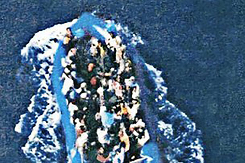
Reconnaissance picture of the “left-to-die boat” taken by a French patrol aircraft on 27 March 2011.
To quote this paper: Heller, Charles and Pezzani, Lorenzo, "Drifting Images, Liquid Traces: Disrupting the aesthetic regime of the EU’s maritime frontier", published on December 10, 2017, antiAtlas Journal #2 | 2017, online, URL : https://www.antiatlas-journal.net/02-drifting-images-liquid-traces-disrupting-the-aesthetic-regime-of-the-EU-s-maritime-frontier, accesed on date.
Introduction
1 Since the beginning of what has been called the “migration crisis” in the Mediterranean, international media have been flooded by images of overcrowded boats crossing the EU’s maritime frontier. Mostly produced either by state agencies or embedded journalists, these images circulate indefinitely, often loosing any reference to the context in which they were initially taken. A little experiment we operated is revealing. Using Google search engine with the criteria “immigrant, boat, Mediterranean”, produced tens of thousands similar images (fig. 1). We clicked on one of the first results, which appeared to epitomize the migrant boat. The particular image was linked to an article in The Guardian dated 29 March 2012 (fig. 2). Here its caption read: “Many migrants and refugees risk their lives to cross the Mediterranean from Africa to Europe. Photograph: AFP/Getty Images”. As the evasive and undated caption should suffice to indicate, this is a generic image, one which, in its media circulation, has lost any remnant of photography’s indexicality and no longer points to a specific event. This image continues to drift from article to article to this day – it has become a “floating image” in the terms of Hito Steyerl. In effect, Google’s search engine found this image to have appeared over 180 times, at many other dates and in different media. This image continues to drift from article to article to this day – it has become a “floating image” in the terms of Hito Steyerl (2013, 171). Unmoored, anonymous, perpetually dispersed, it echoes the conditions of the subjects it depicts. No longer pointing to a specific event, this and thousands of other similar images are practically interchangeable in their use: they evoke the idea of a structural event, that of the precarious boat overloaded with “poor” and “coloured” people breaching the borders of sanctified white and wealthy Europe. next...
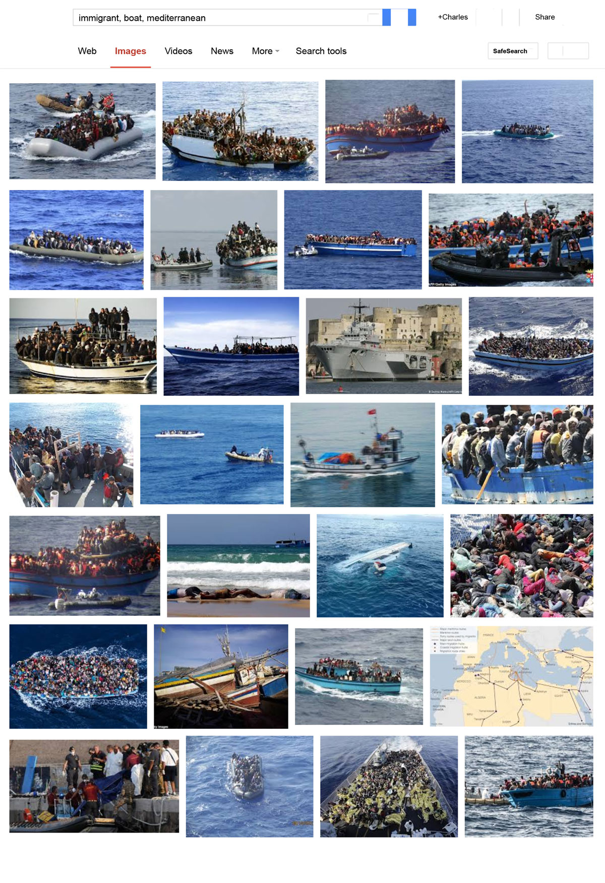
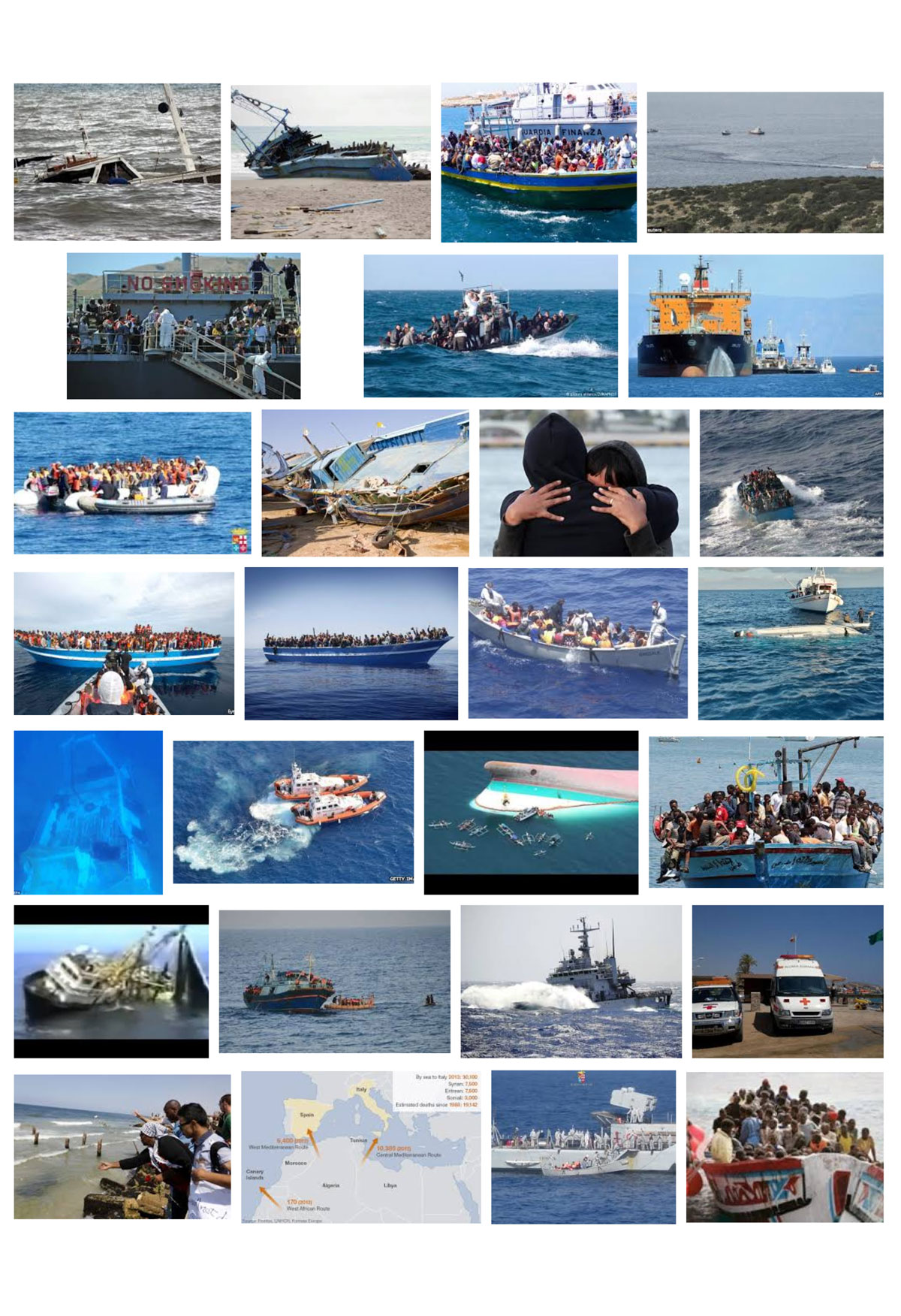
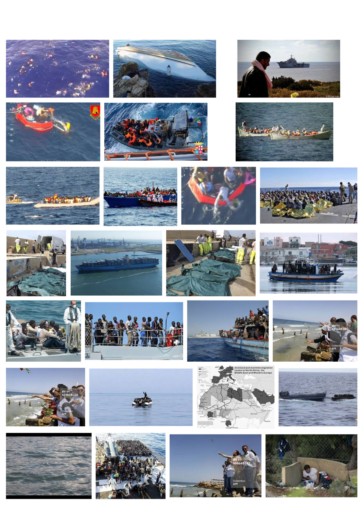
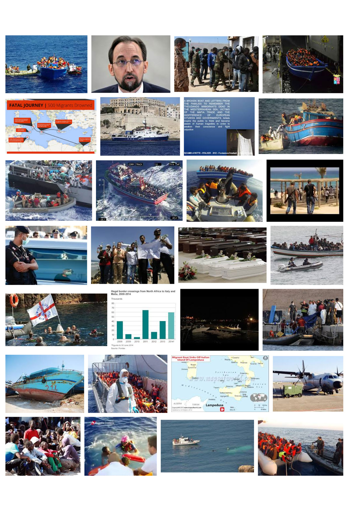
Figure 1: Screen capture of Google’s search engine search for images with the terms “immigrant, boat, Mediterranean”, accessed 16 October 2014.
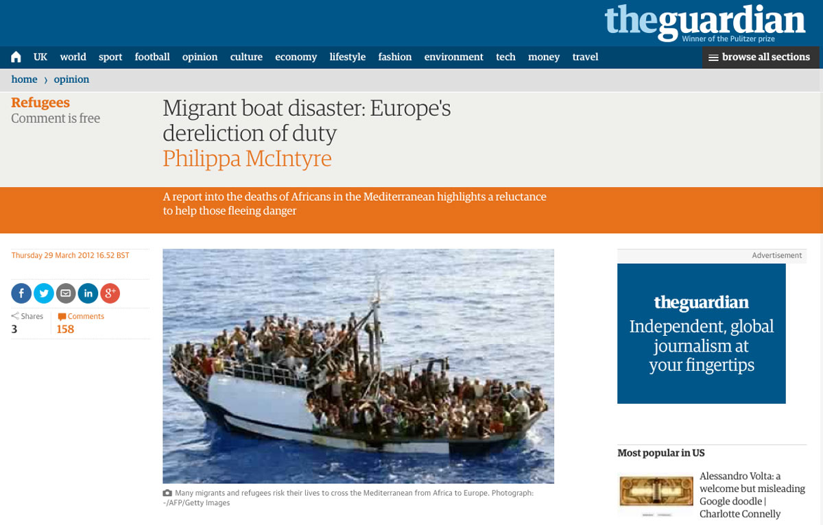
Figure 2: Screen capture of The Guardian article “Migrant boat disaster: Europe’s dereliction of duty”, Philippa McIntyre, 29 March 2012, accessed 16 October 2014.
2 In seeking to re-moor this floating image to the conditions of its production, but in absence of any date or description of the events it depicted, we could only follow the lead of the image’s credits indicating its legal owners: “AFP/Getty Images”. A new search on the online AFP image archive with the term “migrant” produced over 17,000 results. The image in question was catalogued as item PAR2176581 (fig. 3) and indicated to have been released on the 25th of September 2008 by the French Navy. Here the image was accompanied with a longer caption, describing it as showing “a fishing boat carrying 300 illegal migrants in the Mediterranean sea, before their interception on September 24, by a French naval vessel patrolling for the EU border security agency Frontex. The French navy released the migrants to the Italian authorities on the island of Lampedusa.” Searching for further information about this event, w quickly found that this minimal description of a seemingly smooth sequence of events in fact concealed a much more tumultuous interception: some migrants reported that during the transfer from their vessel to the French military ship, the military fired gunshots in the air. This photograph was thus taken by a military of the French Navy who held a camera in his hand while his fellow crewmembers held machine guns. The camera froze the boat in time while the migrants were being immobilised in space under the threat of violence. The act of photography was thus deeply intertwined with the event it documented. The camera froze the boat in time while the migrants were being immobilised in space under the threat of violence. This image is no less bound to the violence of borders throughout its subsequent circulation in the press. As Nicholas de Genova has powerfully argued, the constant appearance of this and similar images of intercepted/rescued boats in the mainstream media participate in the “the border spectacle” (de Genova 2013). Through them, the threat of illegalised migration and the securitisation work of border control are simultaneously made visible and naturalised, in a circular way. If migrants are being intercepted through militarised means, it is because they are a threat. If they are a threat, then they must be policed with all necessary means. However, by focusing on the scene of border enforcement, the conditions that lie before – the state production of illegality through policies of exclusion – and after – the future exploitation of illegalised migrant labour – remain hidden as an obscene supplement. So do the structural violations that are the product of the migration regime. When images revealing the violence of borders exist, states seek to keep them invisible. This was the case in what came to be known as the “left-to-die boat” case, which we have investigated in collaboration with a coalition of NGOs led by the GISTI and the FIDH in the frame of a project called “Forensic Oceanography”.
next...
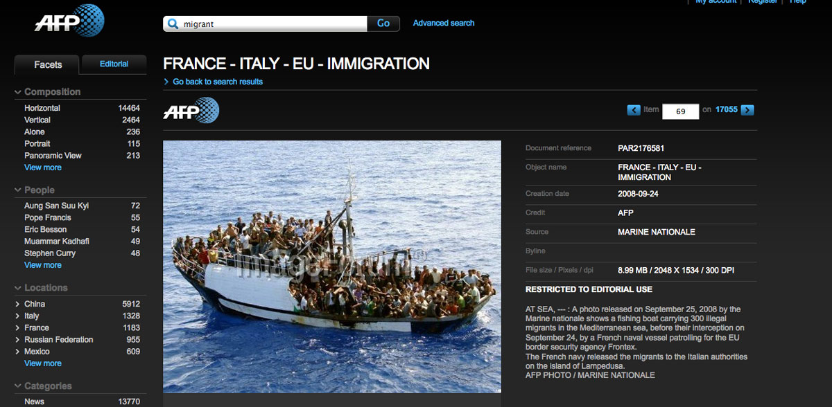
Figure 3: Screen capture of AFP image archive showing the migrants’ boat image released by the French Navy on September 25, 2008, accessed 16 October 2014.
3 In March 2011, at the height of the NATO led military intervention in against Libya, 72 migrants fleeing Libya were left to drift in the Central Mediterranean for 15 days, despite distress signals sent out to all vessels navigating in this area, and several encounters with military aircrafts and a warship. The reluctance of all actors to rescue the drifting passengers led to the slow death of 63 people. Several photographs were taken at different moments during these tragic events, but only one of them has been made public: that taken by a French surveillance aircraft during the first day of the migrants’ journey (fig. 4), which has been revealed by an investigation by the Council of Europe. Several other photographs have remained inaccessible and continued to haunt our investigation. In the interviews conducted with the nine survivors, they describe how at the end of their 1st day of navigation they were flown over twice by a military helicopter from which military personnel photographed them waving and crying for help before fading into the night. Contrary to the passengers’ hopes, no rescue operation was ever dispatched following these sightings. After ten days of drift, when almost half the passengers onboard had already died, the boat was approached by a military warship which came up to 10 m. Dan Haile Gebre, one of the survivors, recalls this encounter: “We are watching them, they are watching us. We are showing them the dead bodies, children. We drank water from the sea, we cried. The people on the boat took pictures, nothing else.” In failing to assist the drifting passengers in all knowledge of their fate, the crew on board this military ship – which remains unidentified to this day – killed them without touching their bodies. We have often pondered the relation between the act of photography and that of non-assistance. For Susan Sontag, the act of photographing, which seeks to keep things as they are “at least for as long as it takes to get a ‘good’ picture”, is fundamentally “an act of non-intervention”, that is complicit with the forms of human suffering it documents (Sontag 1977, 11-12). While Sontag’s argument allows to point to these intertwined forms of deadly non-intervention, it cannot describe all acts of photographing, starting by that of the migrants who recounted to us how they themselves documented the entire sequence of events with their mobile phones. The encounter between these two boats, one belonging to the most powerful actors on earth, the other to the world’s undesirables, was also an encounter between photographers, with each photographing each other. While in the case of the military, photography was an inextricable part of the act of non-intervention, the drifting passengers held their mobile phone while they were crying and begging for the military to intervene to avert their tragic fate. Photography has thus been strikingly embedded in the entire chain of events of the “left-to-die boat” case. While these different photographs would have supplied irrefutable evidence of the crime of non-assistance, they have so far remained out for reach. The images taken by the migrants are likely to have been destroyed when their mobile phones were confiscated when they were imprisoned upon drifting back to the Libyan shore. Those taken by the military probably still exist somewhere, stored on a flash card or on computer hard-drive, but have so far remained inaccessible to any investigation. In this the concealing of the photographs exemplifies the ambivalence of the “partition of the sensible” of the EU’s maritime frontier, oscillating between controlled spectacularisation of border enforcement and the occlusion of the violence perpetrated against migrants (Rancière 2000). In the absence of these incriminating photographs, our investigation on the “left-to-die boat” case attempted to reconstruct a composite image of events by working with the “weak signals” that underpin truth production practices in the field that Thomas Keenan, after Allan Sekula, has called “counter-forensics” (Weizman 2014, 29).
next...
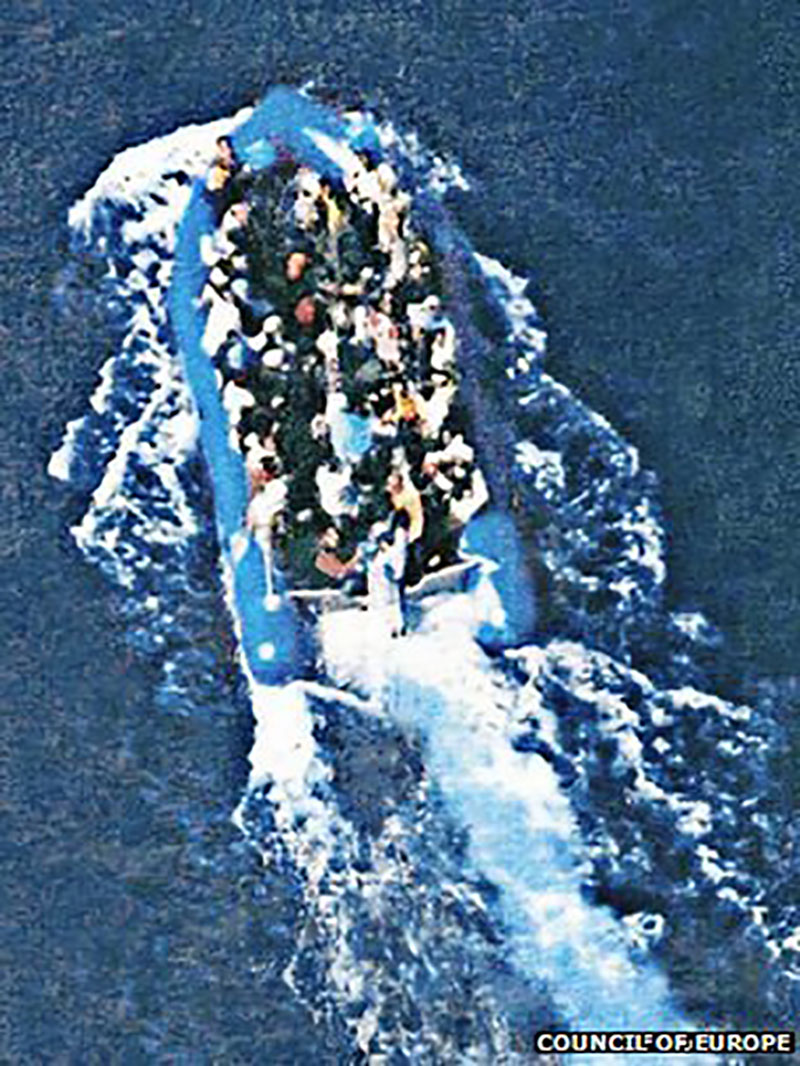
Figure 4: Reconnaissance picture of the “left-to-die boat” taken by a French patrol aircraft on 27 March 2011.
4 The notion of forensics mobilized here does not allude only to the application of scientific techniques to a judicial context, as in the traditional definition of forensic science, but refers more widely to “the art of the forum, the practice and skill of presenting an argument before a professional, political or legal gathering”. While the modern history of forensics is one in which states have sought to police individuals through the development of scientific techniques used to document their violations of the law, inscribing in the process a hierarchy between the testimony of the victims of violence - often deemed unreliable because politically skewed or marked by trauma - with the “certitude” of “objective” science, we were on the other hand committed to the possibilities of turning forensics into a counter-hegemonic practice able to invert the relation between individuals and states, to challenge and resist state and corporate violence and the tyranny of their truth While the modern history of forensics is one in which states have sought to police individuals through the development of scientific techniques used to document their violations of the law In order to do so, we had to go against a well-engrained image of the sea as an empty and lawless expanse. Roland Barthes famously described the ocean as a “non-signifying field” that “bears no message” (Barthes 1972, 112) and Henri David Thoreau wrote that “we do not associate the idea of antiquity with the ocean, nor wonder how it looked a thousand years ago, as we do of the land, for it was equally wild and unfathomable anyways” (Thoreau 2010). But it was not only writers who expressed this perception of the sea as a savage space without history : Carl Schmitt famously described the sea as an anarchic space in which the impossibility of drawing long-standing and identifiable boundaries made it impossible for European states to establish durable legal order or found claims of sovereignty. “The sea,” he wrote, “has no character, in the original sense of the word, which comes from the Greek charassein, meaning to engrave, to scratch, to imprint” (Schmitt 2003, 42-43). If geography expresses, in its very etymology, the possibility to write and therefore read the surface of the earth, the liquid territory of the sea seems then to stand as the absolute challenge to visual and spatial analysis. And yet, nothing appears further from reality once we start to look at the sea a bit more closely. The image reproduced at figure five was taken on the 28th of March 2011 by the European Space Agency’s Envisat satellite and depicts a portion of the Strait of Sicily between the coast of Libya, in the lower left corner, and Malta, in the upper portion of the image. As a “Synthetic Aperture Radar (SAR)” image, it was not created by an optical sensor, but rather by the reflection of the satellite’s beamed microwaves on the sea’s surface. If we look carefully at this image, we begin to distinguish different textures that clearly disprove the popular image of the sea mentioned above. A remote sensing specialist would be able to indicate, for instance, that the darker area that crosses the whole image diagonally, at times bordered by wave patterns, represents an area of calmer sea. The sharply defined dark feature in the mid-left portion of the image, instead, represents probably a oil slick caused by illegal tank-washing. When released on the surface of the sea, oil decreases the amount of microwaves scattered back to the satellite, hence appearing as a black hole, a veritable information gap. Just below that, a striping pattern was most likely caused by an error in the sensor response. Finally, the brighter dots scattered across the image represent large ships. Emerging at the intersection of electromagnetic and physical waves, what we see here is not simply a new representation of the ocean, but a new ocean altogether, one simultaneously composed of matter and media.
next...
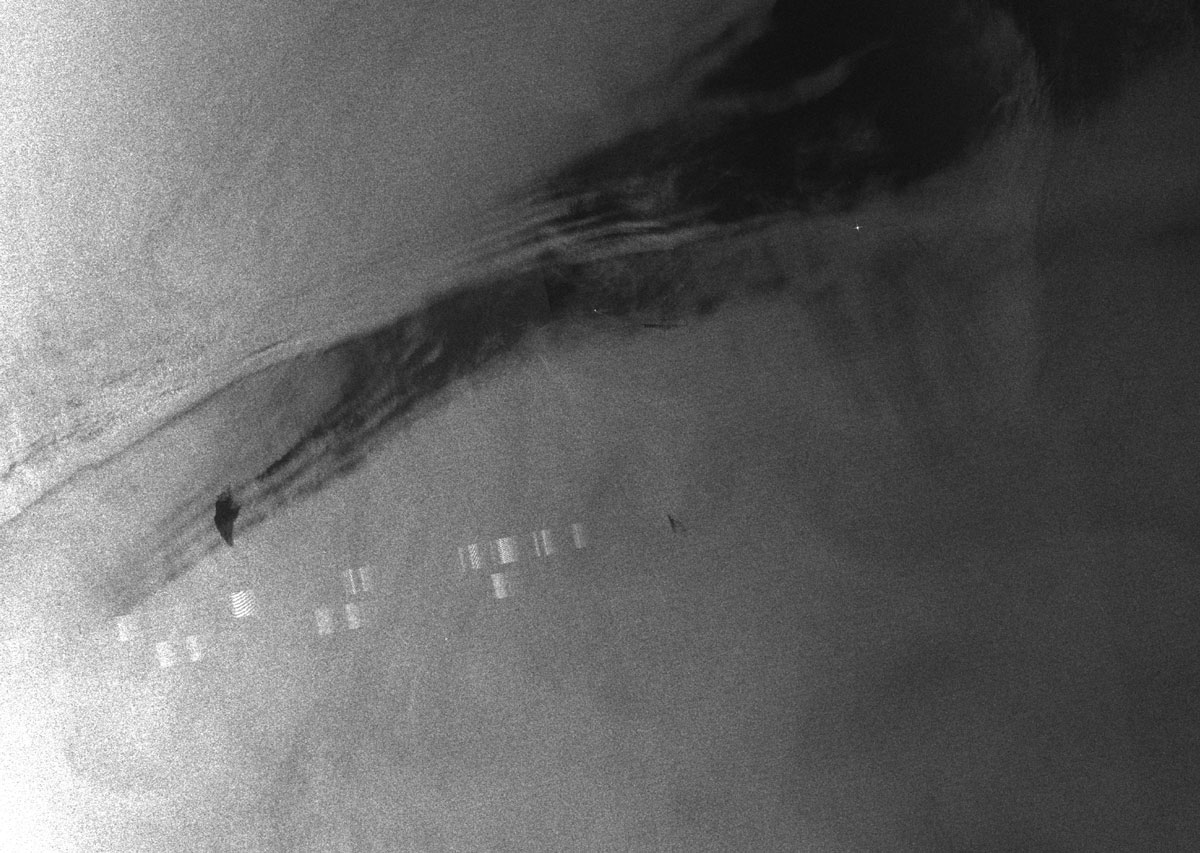
Figure 5: Synthetic Aperture Radar (SAR) image taken on the 28th of March 2011 by the European Space Agency’s Envisat satellite and zooms.
5 Images such as this one are routinely used for the policing of illegalized migration, but in the frame of our investigation into the “left-to-die boat” case, we repurposed it as evidence of the crime of non-assistance. By combining this image with a drift model that maps the trajectory of the boat after it ran out of fuel (fig. 6 and 7), we were able to establish that the bright pixels appearing in the image represent large ships that were located in the vicinity of the migrants’ boat just as it had ran out of fuel and began to drift. All vessels in the area had been informed of the distress of the passengers on board the migrants’ boat as well as its position and could have easily rescued them but chose not to intervene. Satellite imagery is one of the many techniques that we have used to offer an alternative reading of the ocean and of this dramatic event. In the absence of external witnesses, we corroborated the survivors’ testimonies by mobilizing against the grain the vast apparatus of remote sensing devices (optical and thermal cameras, radars, tracking and satellite imaging technologies), which have transformed the contemporary ocean into a vast and technologically mediated sensorium. While these technologies are often used for the purpose of policing illegalized migration as well as other “threats”, they have been used in this case to reconstruct and map with precision what happened to this vessel. Instead of replicating the technological eye of policing and its untenable promise of full-spectrum visibility, we chose to exercise what we have called a “disobedient gaze”, redirecting the light shed by the surveillance apparatus away from “illegalized” migration and back towards the act of policing itself. The technical characteristics of these satellite images are crucial to understand so as distinguish our practice from the technological gaze of surveillance. What the satellite image mentioned above does not show, in fact, are all migrants’ boats that are possibly to be found within its frame. Considering that a migrants’ boat is rarely bigger than 20-25m and that this image has a 75m resolution (meaning that 1 pixel corresponds to 75m), it is easy to see how such vessels would not appear as they remain below the threshold of detectability due to their small size and the low resolution of the image. This meant that, while the position of the “left-to-die boat” was known to us thanks to the drift model, the only other vessels that appear on this image are the bigger commercial and military vessels whose position (and inaction) we wanted to document and not the migrants’ boat whose trajectories are didn’t want to give away. The resolution of the image became then a highly political issue, in that it not only determined the frontier between the visible and invisible, but also separated the practice of a disobedient gaze from an uncritical act of revealing that risks complicity with the surveillance apparatus. This threshold of detectability, that defines the limits of what we can know, is encoded in medial forms and bound up with the techno-political and material assemblages that constitute the Mediterranean scopic regime. In our investigation we thus had to work against the Mediterranean frontier’s “partition of the sensible” (Rancière 2000), piecing together several others fragments of information scattered across a vast assemblage of human and non-human feeds so as to contest the invisibilisation of the violence of borders. Through a process of “trawling through, looking at, and looking again, interpreting, verifying, decoding and amplifying messages and broadcasting them further” (Weizman 2014, 29), we managed to assemble a coherent narrative that was the basis for several ongoing legal cases against the militaries who were in operation at the time of the events – including the French ones.
next...
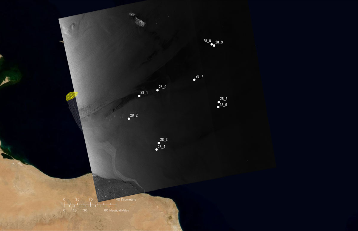
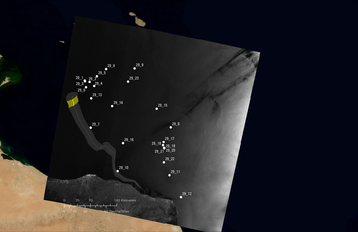
Figure 6 and 7: Analysis of the 28th of March and 29th of March 2011 Envisat satellite images showing the modelled position of the “left-to-die boat” (yellow diagonal hatch) and the nearby presence of several military vessels who did not intervene to rescue the migrants.
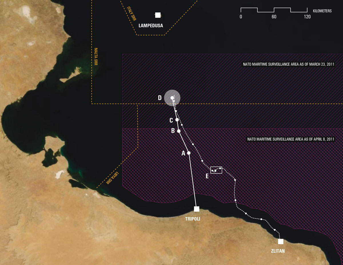
Figure 8: Chain of events in the “left-to-die boat” case as reconstructed by Forensic Oceanography. For a detailed key to this map, see: http://www.forensic-architecture.org/case/left-die-boat/
6 On the one hand, then, our work was a process of image analysis and production that aimed at challenging the current regime of (in-)visibility of the maritime border. Equally crucial, however, has been the possibility to “spatialize” and associate every moment in the migrants’ boat trajectory to a precise georeferenced location. Because of the complex legal structure of the Mediterranean and the high number of actors operating there during the time of the event in question, creating a coherent spatial picture was critical for determining the degree of involvement of each of these parties. At sea, the moment of border crossing is expanded into a process that can last several days and extends across an uneven and heterogeneous territory that sits outside the exclusive reach of any single polity and “in which the gaps and discrepancies between legal borders become uncertain and contested” (Neilson 2010, 126). As soon as a migrants’ boat starts navigating, it passes through the various jurisdictional regimes that crisscross the Mediterranean (from the various areas defined in the UN Convention on the Laws of the Sea to Search and Rescue regions, from ecological and archaeological protection zones to areas of maritime surveillance). At the same time, it is caught between a multiplicity of legal regimes that depend on the juridical status applied to those onboard (refugees, economic migrants, illegals, etc.), on the rationale of the operations that involve them (rescue, interception, etc.) and on many other factors. These overlaps, conflicts of delimitation, and differing interpretations are not a malfunctions but rather a structural characteristic of the maritime frontier that has been often mobilised to produce violence and escape responsibility for it. It has allowed, for instance, different actors at sea to carry out unlawful pushbacks or to refrain from engaging in rescue operations, as in the left-to-die case. Here, it is not the absence of law, but rather the proliferation and spatial entanglement of different legal regimes that produces violence on a large scale. As the tragic events of the “left-to-die boat” case show, images and maps do not simply document the violence of borders, but actively participate in it. It is because of this distinctly spatial dimension of violence at sea that mapping has represented such an important aspect of our investigation: if violence is made through space, mapping can help locate the indices of the structural violence of the maritime frontier. In the specific case of the “left-to-die boat”, mapping has been useful to re-inscribe responsibility across the complex legal geography of the sea. Plotting the trajectory covered by the boat onto the various jurisdictional areas of the Mediterranean was crucial in pointing to the multiplicity of agencies that, at different times, had specific responsibility for the rescue operations but did not intervene. By revealing the path of a “failed” migration attempt, it also provided a very striking counterpoint to the maps of migration that we are used to see, where the presence of big arrows pointing form Northern Africa to European shores is essential to underpin what has been called the “myth of invasion” (De Haas 2008, 1305). As the tragic events of the “left-to-die boat” case show, images and maps do not simply document the violence of borders, but actively participate in it. Whether it is through the logic of the spectacle or of that of state secrecy, the very act of exclusion that underpins the EU’s politics of migration takes place as well within and through its various visualisations. Struggling for the rights of migrants, then, means also intervening in this regime of (in)visibility and claiming a right to look that would be able to challenge the borders of what can be seen and heard. next...
Bibliography
7 Barthes, Roland, 1972, Mythologies, Annette Lavers (éd. et trad.), New York, Hill and Wang.
de Genova, Nicholas, 2013, « Spectacles of migrant “illegality”: the scene of exclusion, the obscene of inclusion », Ethnic and Racial Studies 36.7, p. 1180-1198.
De Haas, Hein, 2008, « The Myth of Invasion: The Inconvenient Realities of African Migration to Europe », Third World Quarterly 29 (7), p. 1305-1322.
Neilson, Brett, 2010, « Between Governance and Sovereignty: Remaking the Borderscape to Australia’s North », Local-Global Journal, 8, p. 124-140.
Rancière, Jacques, 2000, Le partage du sensible, Paris, La fabrique.
Schmitt, Carl, 2003, The Nomos of the Earth in the International Law of the Jus Publicum Europaeum, New York, Telos Press.
Sontag, Susan, 1977, Sur la photographie, New York, Anchor Books.
Steyerl, Hito, 2013, The Wretched of the Screen, Berlin, Sternberg Press.
Thoreau, H.D., 2010, Cape Cod, http://www.gutenberg.org/etext/34392 (Accessed February 8, 2013).
Weizman, Eyal, 2014, « Forensis: Introduction », in Forensic Architecture, Forensis: The Architecture of Public Truth, Berlin, Sternberg Press, p. 9-32.
http://www.antiatlas-journal.net/pdf/02-Heller-Pezzani-drifting-images-liquid-traces-disrupting-the-aesthetic-regime-of-the-EU-s-maritime-frontier.pdf
Notes
1. http://www.imageforum-diffusion.afp.com/ (accessed May 2015).
2. See http://fortresseurope.blogspot.com/2006/01/lampedusa-mitra-sulle-navi-francesi-di.html (accessed May 2015). See the reply of the French authorities: http://questions.assemblee-nationale.fr/q13/13-31911QE.htm (accessed May 2015).
3. For our reconstruction of these events, see our report: https://www.fidh.org/IMG/pdf/final_draftfrench_public_light.pdf . Our video animation Liquid Traces summarizes our findings: https://vimeo.com/128919244 .
4. Parliamentary Assembly of the Council of Europe (PACE), 2012, “Lives lost in the Mediterranean Sea: who is responsible?”.
5. The full interview of Dan Haile Gebre, is available here: http://www.forensic-architecture.org/case/left-die-boat/
6. This definition stems from the work that we have carried out together with the members of the Centre for Research Architecture at Goldsmiths, University of London, in the frame of Forensic Architecture, an investigation on the use of aesthetic objects (video images, satellite imagery, architectural plans and models, maps, audio recordings, etc.) within the legal sphere as evidence of human rights violations. See: http://www.forensic-architecture.org