antiAtlas Journal #3, 2019
Informal Markets and Fuzzy Flows in Fragile Border Zones
Edward Boyle and Mirza Zulfiqur Rahman
In this paper, we examine differences in how fragile borders are perceived by states and those resident along them. As the current policy of fencing indicates, India is conscious of the fragility of the Bangladesh border in Meghalaya. However, local markets on the border show residents able to mitigate its presence, not through ignoring its existence, but in dialogue with the state’s own agents.
Edward Boyle is an assistant professor at the Faculty of Law, Kyushu University, Japan. He researches borders and border spaces in Japan, Georgia, and Northeast India, from the perspective of maps and representation, scalar governance, territoriality, infrastructures, memory and heritage, and history.
Mirza Zulfiqur Rahman holds a PhD in Development Studies from the Indian Institute of Technology (IIT), Guwahati, Assam. He researches Northeast India, particularly transboundary water-sharing and hydropower, connectivity infrastructure, conflict and insurgency, peace-building, development politics, migration, and cross border exchanges.
Keywords: fragile Borders, ways of seeing, visualization, state, local, markets, cross-border exchange, illicitness
Acknowledgements The authors wish to acknowledge the financial support provided by Kyushu University’s Short-term International Research Exchange Program, which funded Edward Boyle’s field trips to Northeast India that made this collaborative venture possible. Parts of this research have been supported by Japan Society for the Promotion of Science (JSPS) KAKENHI Grant Number JP 16K17071. The authors wish to thank two anonymous reviewers for their feedback, which has greatly strengthened the final article. Responsibility for its remaining shortcomings lies entirely with us. Finally, we would like to thank the border residents themselves, for sharing both their stories and their views of the border with us, in frequently trying circumstances.
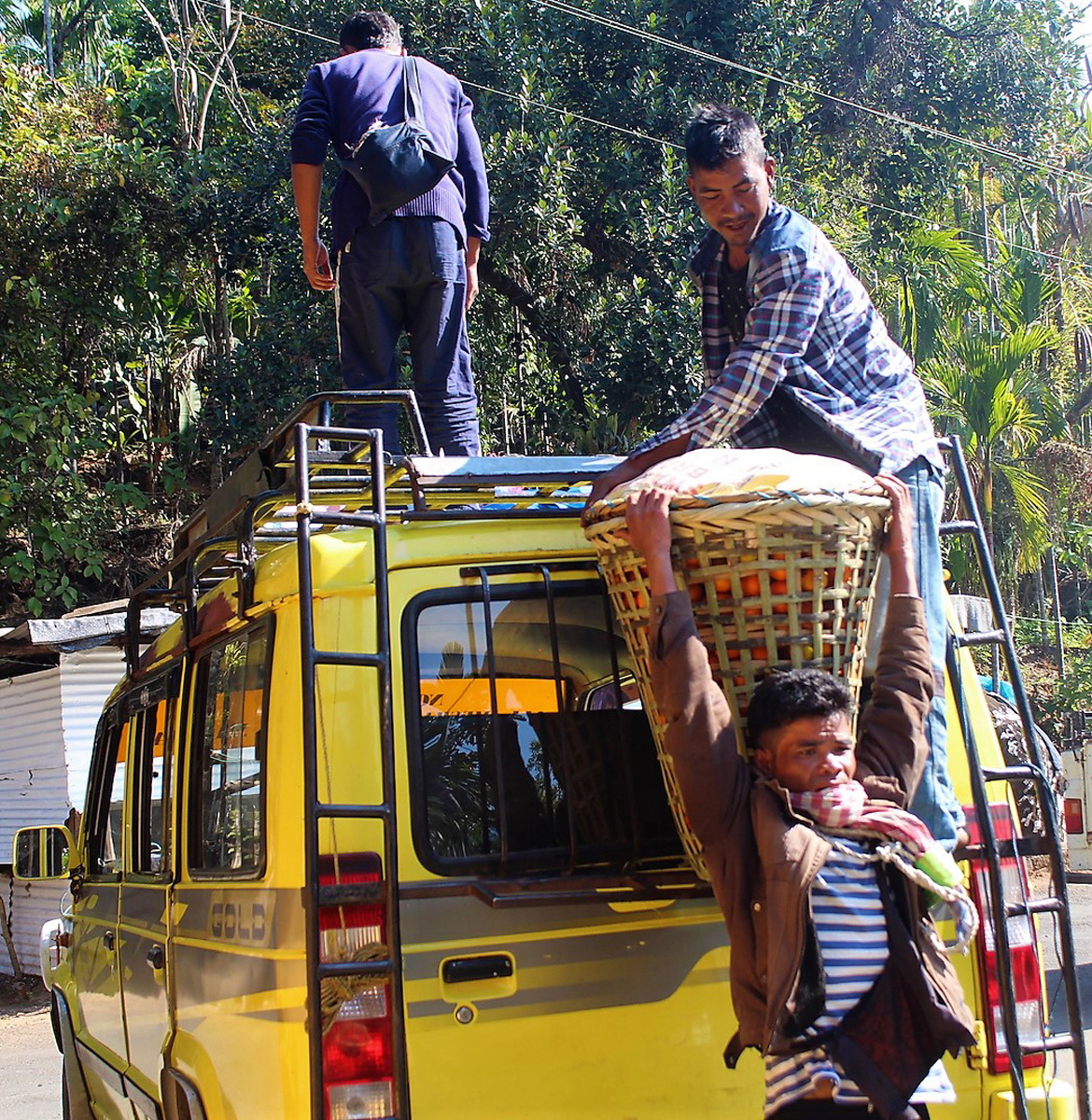
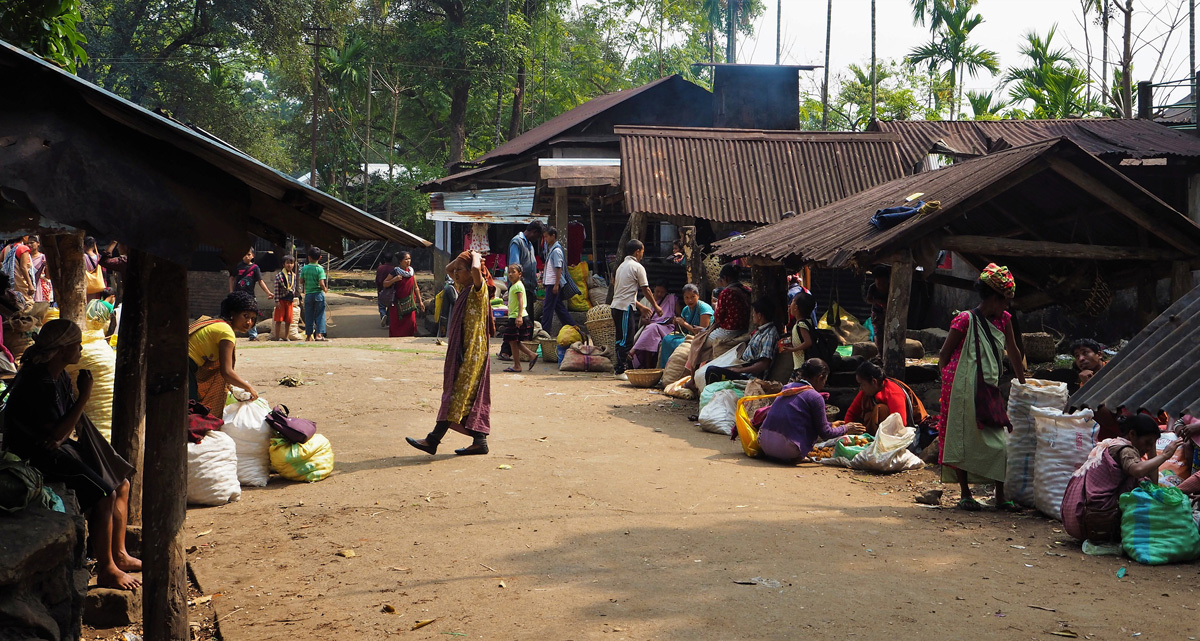
The mandarins reach the road above the market, from where they are taken down to the border.
To quote this article : Boyle, Edward and Rahman, Mirza Zulfiqur, "Informal Markets and Fuzzy Flows in Fragile Border Zones" in antiAtlas Journal #3 | 2019, online, URL : www.antiatlas-journal.net/03-informal-markets-and-fuzzy-flows-in-fragile-border-zones, last consultation on Date
Introduction
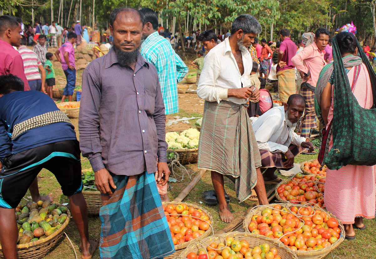
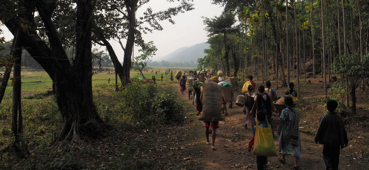
1Holidays often begin with a harvest, and for the inhabitants of one upland region straddling South and Southeast Asia, they start with the harvest of one fruit in particular. The arrival of the winter season to the Northeast Indian state of Meghalaya heralds the coming of oranges to the holiday tables of the province’s devoutly Christian local population. The orange harvest is conducted throughout the band of hills which traverse Meghalaya from East to West. The southern extent of these hills denote the limits of both province and nation, separating Meghalaya and India off from Sylhet and Bangladesh. While the provincial capital of Shillong, at an altitude of 1500 meters, is too high for citrus cultivation, in the valleys to the south leading up to the bustling British-era hill station, the air becomes suffused with oranges over the winter months. Every four days during this period, the sweet, ripe, scent of the Khasi Mandarin rises above the reek of sweat, petrol, and grime at the regular market held in the town of Pynursla, located up 30 km of loosely tarmaced road from the India-Bangladesh border, on the national highway leading to the provincial capital. Attracting locals from the surrounding area as well as traders down from Shillong and up from the foothills, for the best part of three months parts of this market resemble a giant monocolored ball pool, ready for eager buyers, as well as the odd observer, to dive into.
next...
2While many of these oranges ultimately ascend into the hills, others will end up winding their way down to the Sylheti plain to be consumed by the inhabitants of neighbouring Bangladesh, thereby connecting local networks of harvest exchange with the circulation of goods across national borders. Some of this circulation occurs through the institutions of the Government of India, as shown by the presence of “oranges” and “seasonal fruits” in the export data collected at Meghalaya’s official Land Customs Stations. Yet much, and in all likelihood most, of these oranges remain within local networks of exchange as they are moved from one side of the national border to the other. Here, a clear “discrepancy” exists between “official discourse [regarding] control of movement of goods across its borders, and the reality on the ground” (Megoran, Raballand & Bouyjou 2005). This exchange of oranges between communities on opposite sides of the national border taking place all along Meghalaya’s boundary with Bangladesh remains “illegible” to the state (Scott 1998).
From the vantage point of India’s national capital of New Delhi, a distant site of authority and calculation, this inability to “read” what is happening at India’s edges leads to them being understood as profoundly “sensitive space” (Cons 2016). For New Delhi, the border of the Indian nation resembles the skin of the oranges that cross it: comprehensive, all-enveloping, yet also delicate and vulnerable to being punctured. The national border in Meghalaya is thus understood as fragile, open to penetration by a variety of unsanctioned cross-border flows: terrorism, illegal migration, and the smuggling of illegal or illicit goods. Concerns regarding the sensitivity of this border motivate New Delhi’s interest in its securitization, seen in the annual announcements made with regards to fencing the entire length of the India-Bangladesh boundary. The state’s view of the border is shaped by its concern with maintaining and restoring its authority there, and in so doing asserting its status as the primary focal point for those gazing at the border.
References to border “fragility” adopt the view of the state, considering any local networks of exchange that operate without authorization as providing a challenge to its authority. Yet reducing our understanding of the border to the state’s purportedly panoptic gaze restricts our ability to understand the political and economic role of the border itself. Here, the “fragility” of the border does not imply that it has been rendered functionally irrelevant by the actions of non-state groups, merely that the state’s ability to shape views of the border is not absolute. While the understanding of the border held by New Delhi, that of a policed linear boundary standing between the distinct state spaces of India and Bangladesh, does provide one blinkered outlook on the Meghalayan border, for its local inhabitants, the border is also seen through a series of distinct, local, lenses. The various individuals involved in the movement of oranges and other goods across the national boundaries know the border very well, but their view of it is not entirely shaped by the state. This article will deploy images of this border region as it is framed for those involved in local networks of ‘invisible’ exchange in order to elicit a greater understanding of how we should view such fragile borders.
next...

Khasi tangerines
I. Fruitful Frames
3The images selected for this article are intended to provide a visual ethnography of the border through which it is possible to understand how the border is seen by a variety of people. In doing so, it extends the argument, associated with Chris Rumford in particular, that a border is not able to be understood from a single, privileged, vantage point (generally associated with that of the state), and that it must be recognized that the meaning of borders differs depending upon one’s perspective (Rumford 2012). This insight has been drawn upon in other research on the Indo-Bangladesh border, through which it has become apparent that borders are not merely socially-constructed, but are also practiced in different ways at specific locations (Shewly 2016; Ferdoush 2018). This paper seeks to offer multiple visual representations of “everyday experiences and practices at the border” (Doevenspeck 2011, 130), and draws upon a variety of images taken by its authors of or at the Meghalayan border with Bangladesh.
These images provide a means of drawing out the knowledge frames within which experiences and practices are seen and made sense of by participants. Collectively, deployed throughout the body of the article, the imagery is evocative of the border markets the article discusses. It offers a visual representation of the lived experiences of the people involved in constituting the exchanges and spaces of these markets. It is of course recognized that the surface visuals accompanying this article are only able to offer a partial picture of the border. However, these visuals will be supplemented through knowledge about the nature of borders, in order that their particular manifestation here is able to be glimpsed, if only incompletely. In doing so, such images will aid us in showing that there are indeed many “ways of seeing” the space of the border (Berger 1972).
next...
4 In addition to adding context to the narrative that is provided regarding the Meghalayan border and its markets, the aim is for these images to aid in unravelling the themes that the article wishes to address, and elicit the meaning of the text. In order to do so, the images used in the article are deployed as metaphors in order to depict certain core themes of the article. The use of images as metaphors enables the article to make space for the contrasting perspectives held on the market by national and local communities. They therefore contextualize the ability or impossibility of local villagers navigating the various levels of authority embedded in such border spaces and interactions. The images are characters in themselves, capable of evoking information, feelings, and memories (Harper 2002), in this particular case of border markets and spaces and the rules of conduct that constitute them.
These images hold together the narrative of the article, while the visual metaphors that the images provide elicit wider meanings and contexts within which this narrative is embedded. Collectively, they constitute a visual ethnography of this border by offering the view garnered of and by the local communities present in these market spaces, as well as of the exchanges that take place across national borders. The images attempt to bring into focus the divergent ways in which the state and communities view the border, and therefore offer up a competing and contrasting set of border perspectives that emphasize the permeability or impermeability of the boundary line.
next...
II. Bruised Borderlands
5 The attention recently given by the Indian government to the securitisation of the India-Bangladesh border is one that is reflected in the construction of border fences elsewhere in the world (Jones 2012; Vallet and David 2012; Hassner and Wittenberg 2015). While the contemporary ubiquity of such “fortified boundaries” is evidence of a persistent insecurity felt by states about the control of their own extremities, it has also been argued that for India in particular, a persistent national “anxiety” with respect to the boundaries of the state are the result of the nation’s traumatic postcolonial emergence as the Hindu majoritarian rump of British India (Miller 2013; Abraham 2014; Krishna 1994). With Partition, this line drawn at the base of Meghalaya’s hills offered yet another front across which India and Pakistan aggressively eyed one another. Yet in addition to these concerns over the ongoing violence of territorial dismemberment (both in the metaphorical sense of a spatial division (Olsson 2007), and in its very concrete developments over the course of 70 years of separation (Zamindar 2007; Sur 2015)), the fragility of this particular border is accentuated by Meghalaya’s position as a double frontier.
This is because the province is part of India’s Northeast, a region which, as a result of Partition, is territorially-contiguous with the rest of India along the narrowest of corridors, the infamous “chicken’s neck” at Siliguri in West Bengal. Relations between the Northeast and the capital have been persistently blighted by demands for autonomy from a variety of groups in the region, together with the persecution of the uprisings in support of such demands. New Delhi’s response has oscillated between brutal military crackdowns and efforts to accommodate the most intractable of such conflicts, without damaging the authority of the central state. It was the desire to secure state authority in the Northeast which led to the creation of Meghalaya itself, one year after the transformation of East Pakistan into Bangladesh following a brutal civil war in which Bangladeshi guerrillas trained on Indian territory, which was also where its nascent government was based. The Indian state responded to demands for self-determination made by the three major tribes, the Garo, Khasi, and Jaintia, inhabiting the hill districts of a then-unitary Assam, by carving out the border province of Meghalaya on 21 January 1972. This both reflected New Delhi’s acceptance of indigenous aspirations for autonomy, and the belief that smaller provinces at the state’s borders would make for more efficient and effective administration of them (Baruah 1999; Chaube 1999).
next...
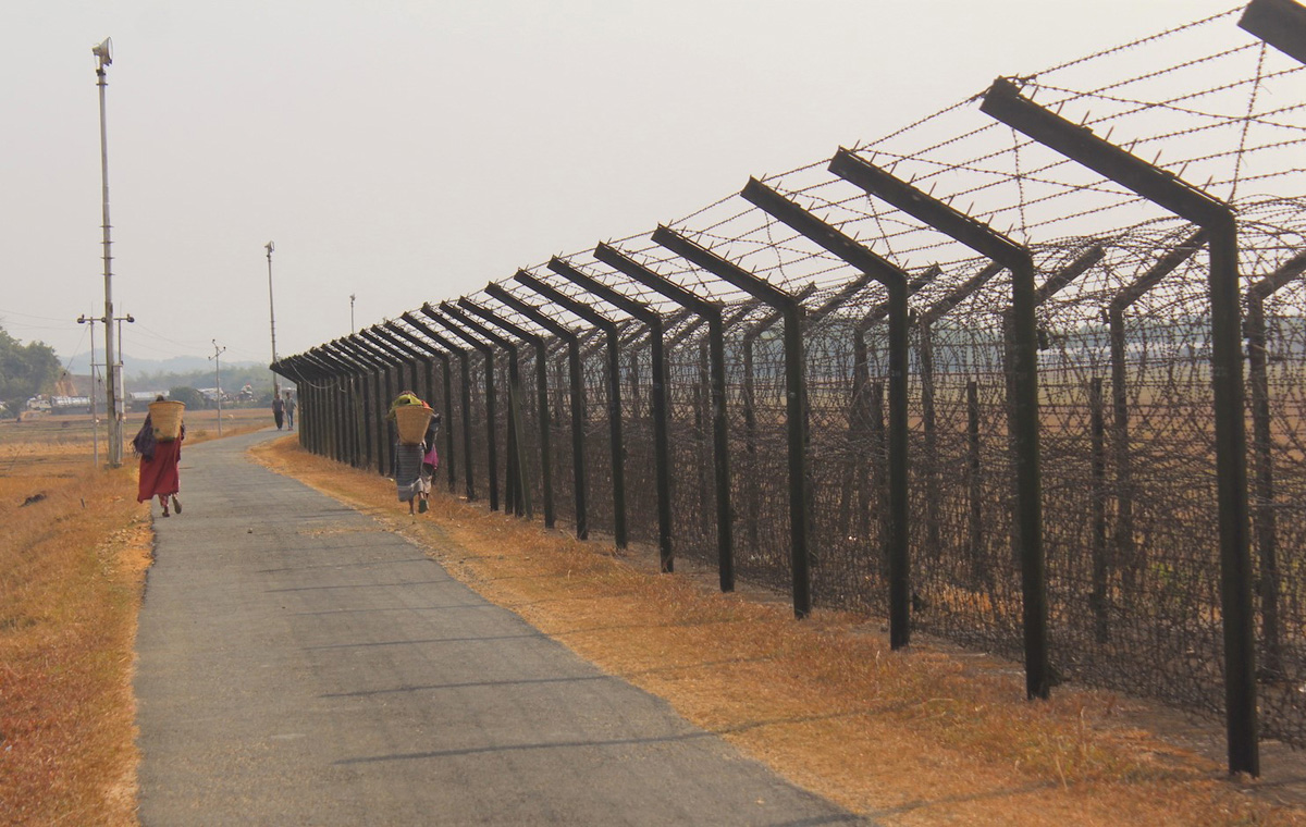
Daily life in Meghalaya along a fenced segment of the India-Bangladesh border.
6 In the event, neither the creation of the new border province of Meghalaya nor the relations that existed between India and Bangladesh, far more cordial than those between India and Pakistan, worked to displace concerns regarding this border. Insecurity heightened along the Meghalayan boundary line in the 1980s, as the Indian army battled a variety of insurgent groups. The conflict entered its most serious phase with the formation of the Hynniewtrep Achik Liberation Council (HALC), which united the three major tribes of the state, the Khasis, Jaintias and Garos, around a common goal of expelling outsiders. Ethnic differences resulted in a split in 1992, with the Hynniewtrep National Liberation Council (HNLC) representing Khasis and Jaintias, and the Achik Matgrik Liberation Army (AMLA) representing the Garos. Today, although an armed struggle for a separate Khasiland continues, the intensity of the conflict has dramatically decreased. By contrast, the demand for Garo separatism continued, initially through two new groups formed in the Garo Hills, during the 2000s (Rahman 2015).
Meghalaya is thus a double frontier, existing as the administrative container for Christian tribal groups who identify themselves largely in opposition to an Indian state seen through the prism of New Delhi, and located at the edge of a region perceived as only weakly connected to the rest of the country. The “friction with the terrain” has made state control of the hills dependent on its relations with the local population (Scott 2010), relations which, here as elsewhere in the Northeast, were poisoned by military atrocities committed in response to insurgent activities. Although the situation in Meghalaya as a whole has improved since the 1990s, other groups from elsewhere in the Northeast continue to base themselves across the border in Bangladesh and to cross into India with relative impunity. Recent media attention given to kidnappings and insurgent violence among the persistently ungovernable Garo Hills indicates the fragility of the state’s hold over this territory, working to justify New Delhi’s perception of these border regions as being vulnerable to flows across the state’s boundaries, and thus the necessity of viewing them through the lens of security.
next...
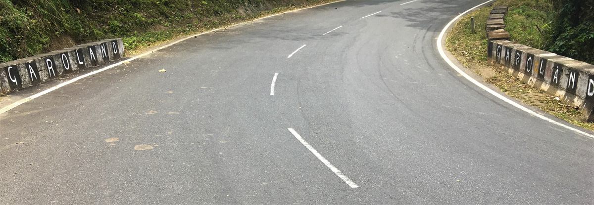
Separatist claims along the national roads in the western Meghalaya.
III. Border Markets
7 The Indian state’s desire to securitize and dominate the border is visible in its determination to fence it. However, this concern with security, along with the connection between political legitimacy and development, has also led to a belated focus on promoting economic growth in the Northeast as a more effective response to local demands than mere repression. In fits and starts, the post-Cold War “liberalization” of the Indian economy has found reflection in a variety of policies that have sought to transform the isolated Northeast region into a zone of connectivity, facilitating Indian connections with both China and Southeast Asia (Das & Thomas 2016; Haokip 2015; Uberoi 2016). Such policies promise to transform the economic structure of these provinces and undo the legacy of Partition, from which the Northeast “inherited boundaries which…were hugely disruptive to traditional avenues of commerce, disregarding of resource endowments, and entirely indifferent to demographic forces and trends” (Wirsing & Das 2016: 49).
Recently, the state has been concerned with overcoming the commercial ‘disruption’ caused by Partition through the establishment of a limited number of border haats on the India-Bangladesh border. Styled as benevolent efforts of concerned governments to extend the current rhetoric of “Acting East” as well as the economic corridors down to the level of remote border communities, these haats are border markets allowing for a cross-border trade in local produce. These markets are constructed on the international zero-line, with one part of the market located on the Indian side of the border and the other in Bangladesh, and theoretically provide a space in which locals from both sides of the border are able to gather and trade together. Such official border haats are presented as revivals of former trade practices (on them, see Boyle and Rahman 2018).
next...
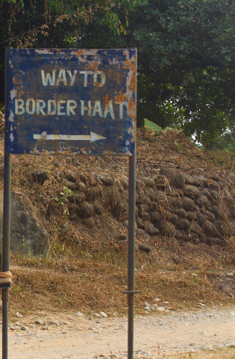
Sign indicating an official border haat, recently established to facilitate trade across the border.
8 The presence of this type of trade in the region is visible in the term ‘haat’ itself, derived from the Mughal-ruled peoples of the Sylheti plains. The term came to be used among the hill peoples of Meghalaya to refer to those markets in which exchange occurred between themselves and those residing on the plains, to distinguish them from other markets held amongst the hill peoples themselves (the latter are known as ‘ya’ amongst the Khasi, for example). This heritage of exchange is visible along the current India-Bangladesh border, adjacent to which are a succession of toponyms speaking to this history of exchange through the addition of ‘haat’ to their names: as Hat Nongjri, Hat Umniuh, Hat Thymmai (also known as Naya Bazar, or ‘new market’) and so on.
Yet such toponyms are not merely indicative of a past history of trade that flowed between the plains and the highland, before the delineation of an international boundary made such trade an international one. Despite a lack of official recognition and increasing pressure being brought to bear on this sort of illicit trade, many of these markets continue to be held. Along this border, a ‘haat’ does not necessarily indicate one of the historical spaces of exchange which existed prior to the severing of traditional flows through the imposition of a modern state border, nor sites of exchange on the modern boundary, mandated and institutionalized by the state. The term can also be used to refer to a series of informal markets held along the border. The remainder of this piece will largely be concerned with displaying and analysing the structure of one of these markets, in order to reveal how the border is seen at them.
next...
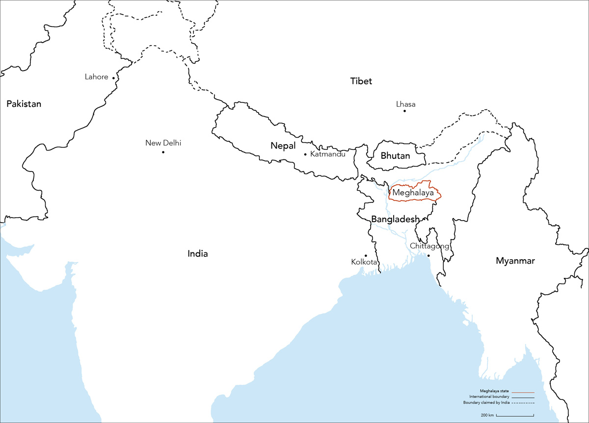
Map showing the position of the Meghalaya in India.
IV. Informal Economies
9 It is through these informal markets that some of the mandarins bought at Pynursla market will find themselves bouncing down the national highway towards the Bangladeshi border on the back of the ubiquitous yellow Sumos (jeeps), heading down to be offered as exchange in an unrecognized ‘international’ trade. Visiting these unofficial markets makes clear that these sorts of local cross-border flows have long been a part of life in the border regions, irrespective of the state’s implicit claims to have put an end to such trade through the imposition of national borders. For people in borderland Khasi communities, such economic flows are sanctioned by custom, with these connections having existed long before the presence of an international border here. What for locals is legal, however, is considered an illegal cross-border trade by the State (van Schendel 2005; more broadly Abraham & van Schendel 2005). New Delhi’s understanding of the functional role of the border, however, has had to date little effect on how the local population is able to see it.
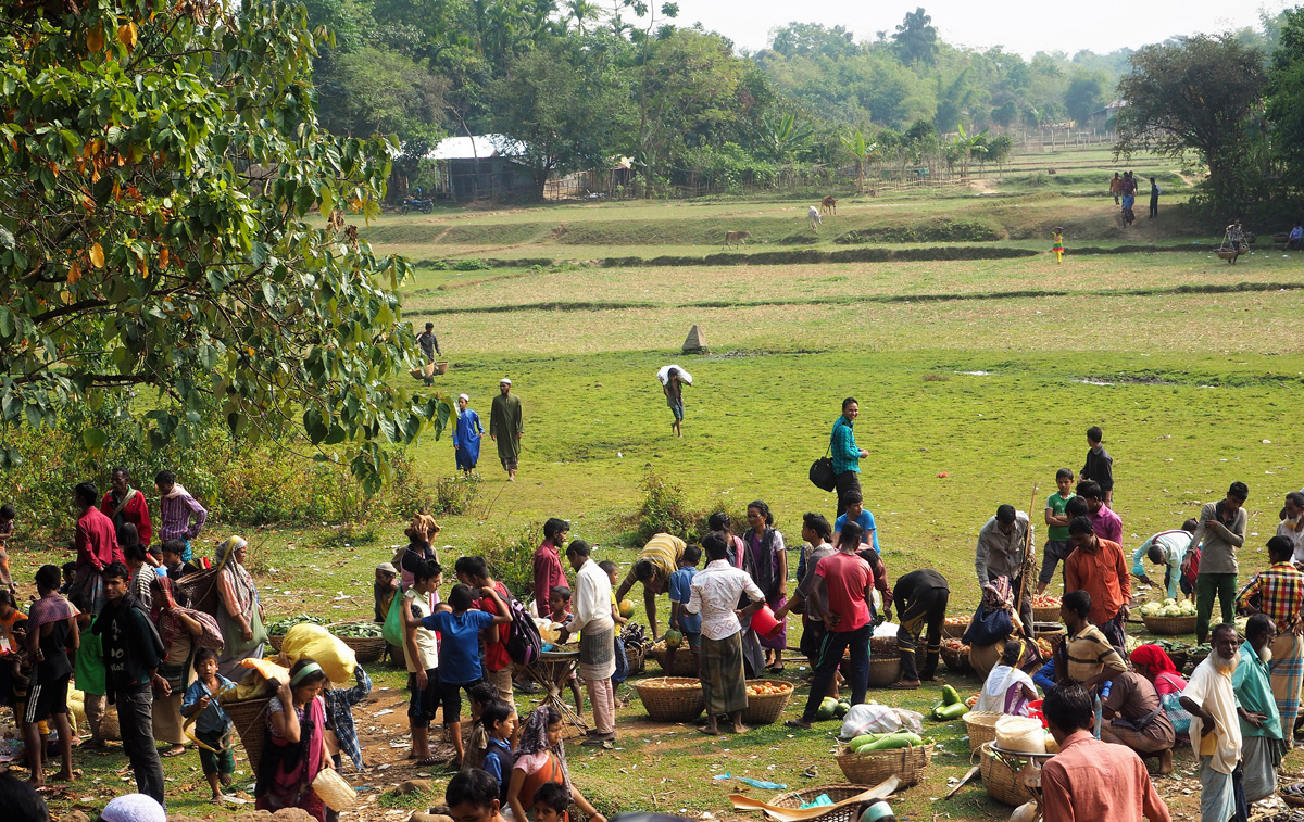
On the Indian side, the holding of the actual cross-border market is preceded by a gathering of the local Khasi tribespeople at a series of more permanent concrete market structures built within Indian territory. This gathering provides testimony to the longevity of a seemingly ramshackle event.
While the market had apparently on occasion been stopped by one side or the other, this had never been for very long. One elderly gentleman claimed the first market he attended was in around 1963, when he would walk for six hours in one direction with a basket of oranges strapped to his back, dropping into a valley, up over a ridge, and finally descending to this market at the foot of the hills. Perhaps fortunately for the local children, the ubiquity of the Sumo had reduced the need for such backbreaking efforts to bring produce to market, with almost all of it now transported in a motorized fashion.
next...
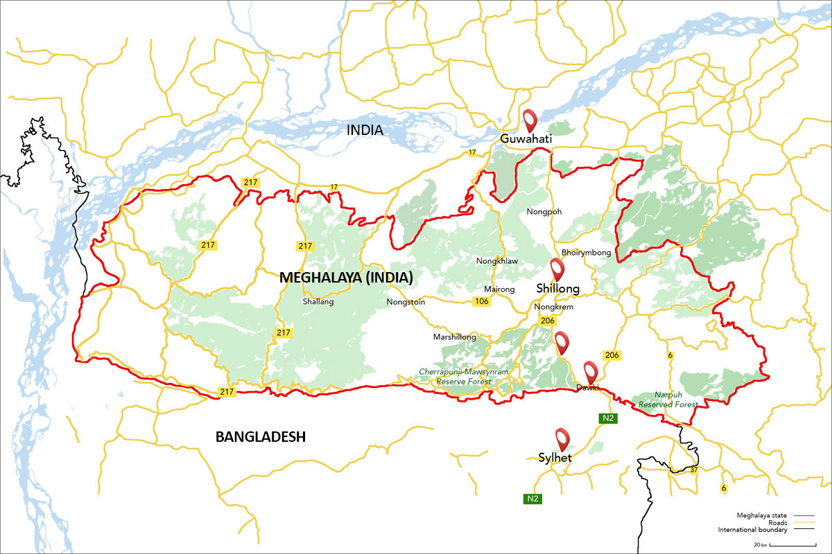
Meghalaya Map
[https://www.google.co.jp/maps/@25.1798151,91.8108621,14.29z?hl=en] Map Data © 2019 Google
The tangerines reach the road above the market, from where they are taken down to the border.
Permanence: the set of precarious hard structures of the permanent market in India, where the Khasi gather before crossing the border.
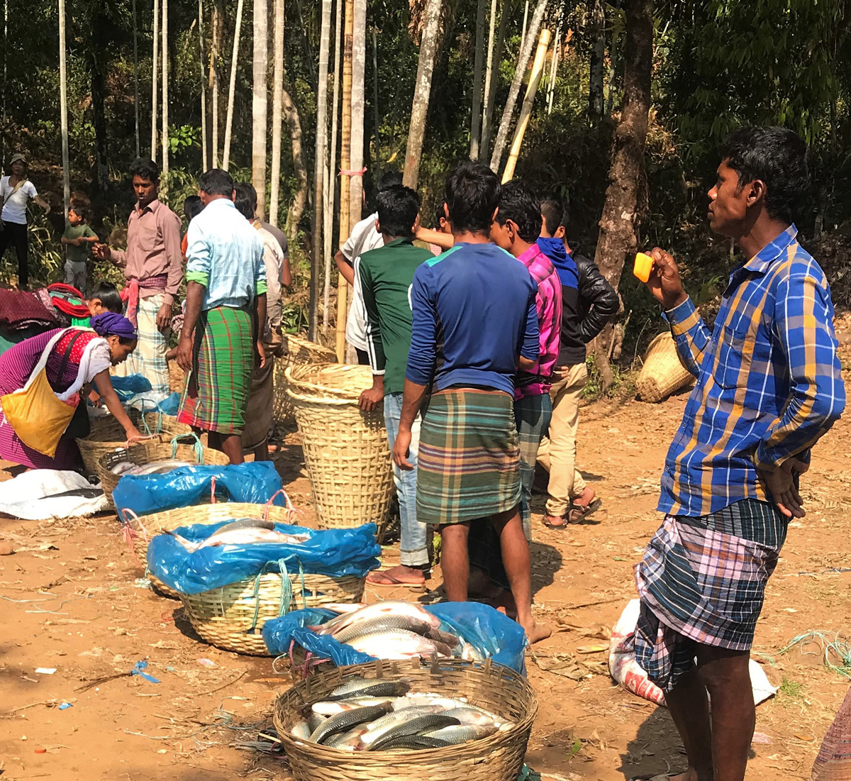
10The longevity of the market, though, indicates its position within a local network of trade that incorporates both sides of the border, in which the market provides regular access to goods drawn from what has become the nation next door. The produce being exchanged at these markets is seasonal, and largely spoilable. In winter, oranges, from villages along the border as well as trucked down from Pynursla, form the main part of the Khasi crop, together with the ever-present betel nuts (with those of Meghalaya reputed to be the strongest available) and gourds, while other parts of the year bring forth different fruits, such as pineapples. In exchange, Bangladeshi traders were offering an array of predominantly farmed produce, aubergines, tomatoes, huge green beans, and cauliflowers, together with fish and less agricultural products like plastic toys and helium balloons, on their side of the market.
The market is typically held in sight of the pillar demarcating the international border, with villagers from the Bangladeshi side physically crossing the border and setting up shop on the Indian side. Although the market is entirely within India’s territory, a spatial distinction between the two groups was maintained, with Bangladeshis setting out their wares in rows at the base of the hills, and the Khasi’s occupying the slightly higher ground above them, reproducing on a small scale their respective local geographies.
next...
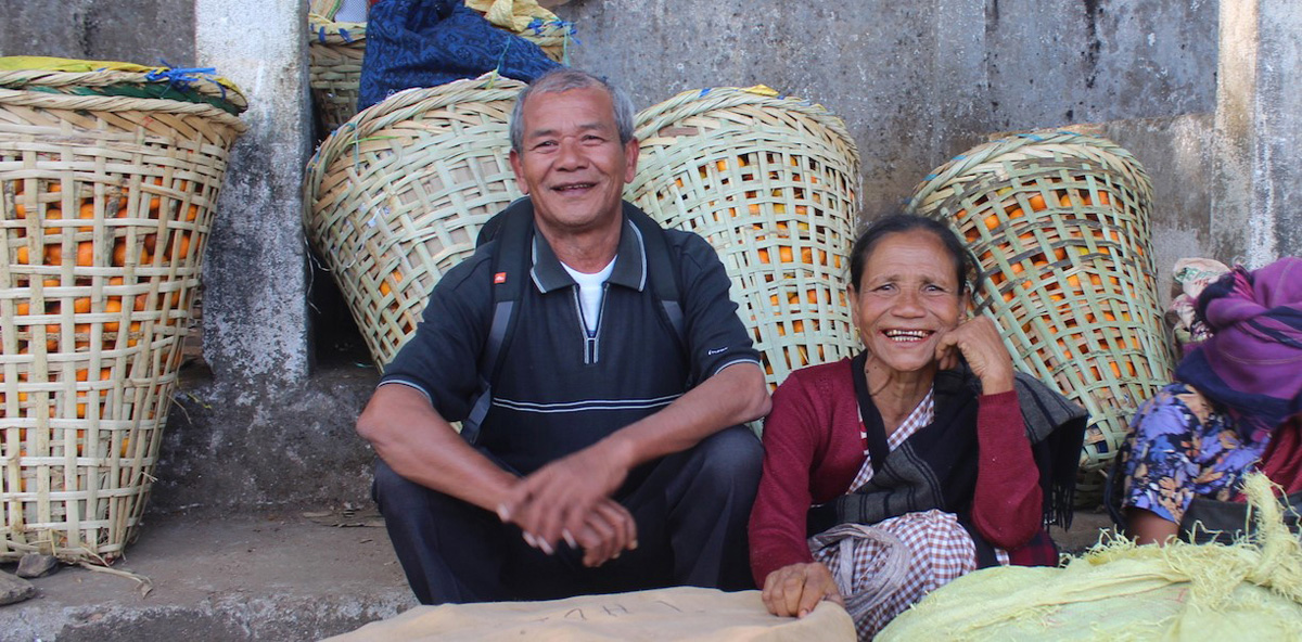
Permanence: a resident of Shillong, who first came to the market as a child in 1963, when he had to walk for 6 hours in the hills with a load of tangerines on his back. We see him here with his sister, who still comes regularly to the market.
A Bangladeshi trader proudly presents his items, vegetables that have grown on the plains of Sylhet and are then transported across the border to be sold to the Khasi of Meghalaya.
11 While these informal spaces of exchange are unsanctioned, it is not entirely accurate to state that these markets take place outside the purview of the state. Members of India’s Border Security Force (BSF), the central armed police force responsible for guarding the nation’s boundaries, patrol and oversee the market. In addition, local members of India’s sizable intelligence apparatus are also frequently in attendance and circulating the area. When the market is held on Indian soil the presence of the BSF is conspicuous. By contrast, their paramilitary equivalent on the other side of the border, Border Guards Bangladesh (BGB), do not really appear at the market, though they are present in the background and have their own points of contact among the Bangladeshi participants.
The timing and duration of the market appears to be largely under the control of the BSF. At a given point, it is adjudged that the time for the market is over, and this is communicated to the local market organizers. These organizers are then responsible for moving through the traders, informing them that the day’s trading is done, and sparking a frenzied round of final negotiations. Both buyers and sellers are once again spatially-separated into distinct national populations, with the Khasis moving back towards their permanent market huts, and the Bangladeshis across national border.
next...
12 The closure of the market does not necessarily signal the end of work for many of the participants, for whom attendance at the market to sell produce serves as merely the first half of the day’s trading, one which continues back in their home villages. This is necessitated by the limited ‘shelf-life’ of much of the produce, a factor which was clearly already of significance during the course of trading itself. This guarantees the local nature of the commodity networks into which the markets fit: Bangladeshis purchasing these oranges would take them back to their own villages and sell them on there, with each village having a number of buyers at the market in order to supply their needs.
It was a similar story on the other side, although on an even smaller scale. For instance, from one particular village, a group of five women descended down to the market in the morning to sell the oranges they had both harvested and acquired locally, and then returned in the afternoon to sell the vegetables and fish they had acquired at the market in the village that same evening. Their profit margins on the latter items were not large, but their relationship was cooperative rather than competitive, and their purchases sufficient to supply the village until the next market was held. Local life along both sides of the border, therefore, is dependent upon and benefits from these markets, which function outside of the state’s gaze.
next...
Installation of the market at the foot of the hills, just at the beginning of the Indian territory. The products are brought from Bangladesh. The international border marker can be seen in the background, with the rice fields of Bangladesh in the distance.
V. Official Borders & Border Officials
13 It is through these informal occasions that the export of “official” oranges, those bouncing on the backs of trucks through border check points at Dawki and elsewhere, come to be accompanied by their subversive citric cousins, which remain unseen by the state when crossing the border. Nevertheless, the inability of the state to see what is crossing the border does not reflect the border’s absence, as it remains inherent in the practice of the market.
The borders of the state are reproduced through the structure of the market itself, which occurs as an exchange between not only Indian and Bangladeshi but between Khasi and Sylheti Bangladeshis, ethnic designations that in this instance map seemingly perfectly onto the citizenship accorded both groups of participants. It also recreates the space of the border in miniature, with a clear divide evident between Bangladeshi and Khasi participants, and traders remaining bunched by ethnicity. The border, then, separating India and Bangladesh is also found to run through through this market space, separating participants from one another. The end of the market is marked by the retreat of buyers of both sides back to ‘their’ spaces on the opposite side of the market and beyond. The international border between India and Bangladesh continues to operate, irrespective of the market’s actual location in space. At the local level, therefore, this border is a “mobile” one, positioned between the two sides wherever the market comes to be located.
This is important because although the market has a regular location, it does not have a permanent one. Furthermore, the time of day at which the market takes place is not fixed, but negotiated each time by those responsible. These negotiations are conducted by the market organizers from both sides of the border, together with the BSF, the BGB, and the land’s owner. It is only following the successful conclusion of these negotiations that a signal is given to the market’s participants to head down to where the market will be held. The market then arranges itself on the open ground at the base of the hills, with the Khasi streaming down to this area from their assembly point further up the path, and being met by their Bangladeshi counterparts freely crossing the border.
next...
Two Khasi women watch the products of a row of Bangladeshi fish vendors at the border market.
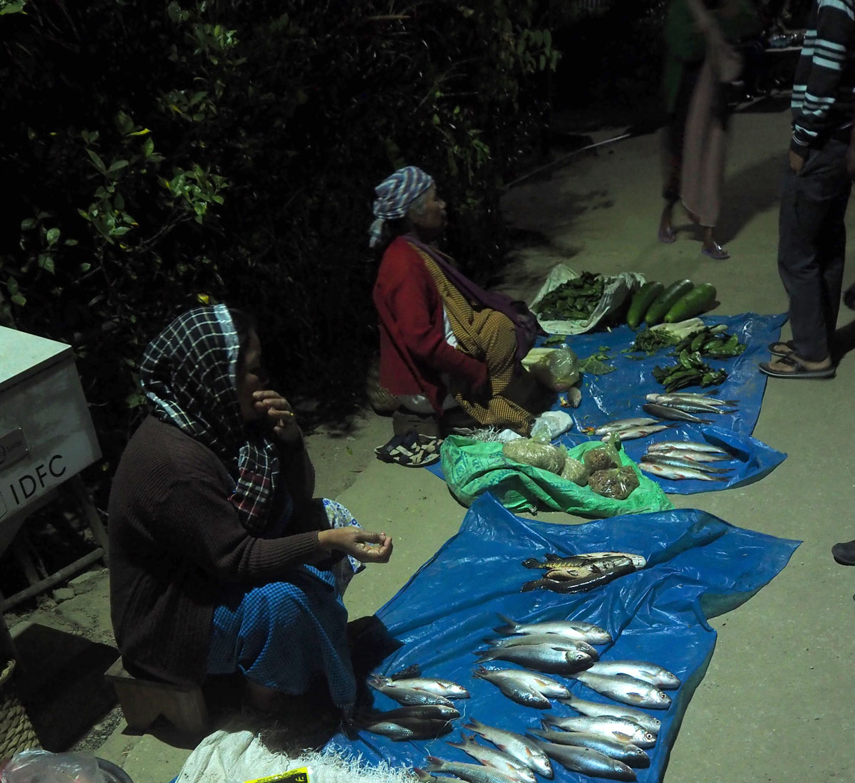
Sale of fish and other products from the border market that evening in a village near the border.
14 It is not, therefore, simply the case that the state is not present at this border, for its agents are indeed present and watching over events. Nevertheless, the market over which they watch is officially not there, and thus while these individuals embody the potential violence of the state in their persons, and serve to show the presence of the state at its limits, their presence cannot be used as a mere shorthand for the state. Despite the presence of agents of state, such events are taking place without the state’s authorization. This is shown by the absence of any immigration and customs procedures, and further by the absence of knowledge about the markets outside of the immediate local level in which they occur. In interviews, customs officials based in Shillong informed the authors that, in the few places it occurs, such local cross-border trade would involve just four or five participants, rather than the entire communities it is capable of mobilizing. The involvement of the state, therefore, like that of the market’s traders and participants, is one that is organized at a local level, and consequently the state’s view from New Delhi is obscured by the behaviour of its own agents.
This extends to the way in which these markets have been informally and illicitly institutionalized with the connivance of these same agents. The process of holding markets is dependent upon negotiations occurring at a more local level, with the local BSF commandants. This necessitates a regular cycle of negotiations associated with the standard three-year terms for BSF deployment, which generally involves an initial effort by newly-appointed officers to “tighten” the border, before the terms for the holding of these markets are worked out between the BSF and local residents. This could be understood as an effort by the state to ensure the security and livelihoods of the local population, except that, as already noted, for the state, these markets do not officially exist. Rather, the credibility of the BSF as an organization that secures the border is dependent upon their continuing to grant permission for these markets to occur.
The maintenance of the border is associated with the provision of spaces of exchange able to be negotiated by the communities on opposite sides of the national border. This provision occurs despite the presence of the state, rather than because of it, but the state’s agents are able to ‘legitimate’ their status through the sanctioning of such spaces of informal exchange (cf. Tilly 1985). In so doing, they come to function like any other armed group, through guaranteeing the security of cross-border flows and exchanges. As such, they become both agents of the state and its subversion, simultaneously maintaining and undermining the border.
next...
On the right: Khasi people are on their way to the market place at the foot of the hills, Bangladeshis crossing the border on the left.
VI. Fuzzy Frames
15 This paper offers a specific empirical examination of the persistence of trade linkages across the boundaries of a modern nation, which continue to operate despite the violence engendered by the state’s sense of insecurity regarding its own margins. The illicit trade that occurs along the India-Bangladesh border in Meghalaya offers a fruitful (pun intended) window into this seemingly paradoxical situation. The Northeast’s isolation from the main body of India, and thus the importance of the long-standing connections existing across the border for communities residing in its vicinity, make it particularly suitable for the study of such local circuits of exchange, which carry innocuous items like the Khasi Mandarin down onto the plains of Bangladesh. This is particularly the case now, as the process of fencing this borderline encompasses more and more of its length.
It is common to view such exchanges as a local challenge to state authority, occurring as they do without authorization, their existence studiously ignored by the centre. Nevertheless, to see them solely in this fashion is to ignore the fact that they are dependent, in the first instance, upon the acceptance by locals of the state’s claims to territory (Dean 2012: 227). Small-scale efforts to subvert official control are conditioned on this acceptance . In the case of the borderline between India and Bangladesh, a rejection of certain aspects of state authority is coupled with an acceptance of its normative claims from the start. While the emphasis placed upon securing the border reflects Delhi’s awareness of the limits of its own authority, this has also provided a degree of latitude for local residents to leverage the state’s concerns in order to receive local autorisation by the state’s agents to engage in trade across the boundary line.
Despite the insistence of the state on maintaining its boundaries, in the foothills of Meghalaya the border continues to be defined as much by passage across the boundary as by the line itself. These flows of people and goods, which allow for the sweet smell of the Khasi Mandarin to waft across the border in the baskets of fruit carried from one side to the other, depend upon the continuous negotiation by locals. The state’s concern with its borders contributes to the fragility of their everyday existence while providing the space within which local exceptions to national imperatives can be arranged. The ways in which this border comes to be seen by locals are ultimately relative and determined; like the orange with which we began, the border here is not smooth, but pitted and uneven.
next...
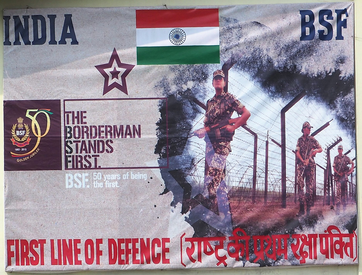
Border Security Force poster near the international border crossing point at Dawki, Meghalaya. The image of the poster shows the border that BSF patrols, fenced and secure, in accordance with the idea of New Delhi, but it is not the border that we see elsewhere along this same international demarcation
Bibliography
16
Abraham, Itty et van Schendel, Willem (eds.), 2005, Illicit Flows and Criminal Things: States, Borders, and the Other Side of Globalization. Bloomington: Indiana University Press.
Abraham, Itty, 2014, How India became territorial: foreign policy, diaspora, geopolitics. Stanford: Stanford University Press.
Baruah, Sanjib, 1999, India against Itself: Assam and the Politics of Nationality. Philadelphia: University of Pennsylvania Press.
Berger, John, 1972, Ways of Seeing. London: Penguin.
Boyle, Edward et Mirza Rahman, M. 2018. “Border Layers: formal and informal markets along the India-Bangladesh Border” in R. Jones & A. Ferdoush (eds.), Borders and Mobility in South Asia and Beyond, Amsterdam: University of Amsterdam Press
Chaube, Shibani K., 1999, Hill Politics in Northeast India. Hyderabad: Orient Longman.
Cons, Jason, 2016, Sensitive Space: Fragmented Territory at the India-Bangladesh Border. Seattle: University of Washington Press.
Das, Gurudas et C. Joshua Thomas (eds.), 2016, Look East to Act East Policy: Implications for India's Northeast. Abingdon, Oxon.: Routledge.
Dean, Karin, 2012, “Space, Territorialities and Ethnography on the Thai-, Sino- and Indo-Myanmar Boundaries” in D. Wastl-Walter, ed., The Ashgate Companion to Border Studies. London: Ashgate Publishing, 219-241.
Doevenspeck, Martin, 2011, “Constructing the border from below: Narratives from the Congolese–Rwandan state boundary.” Political Geography, 30, 129–142.
Ferdoush, Md. Azmeary, 2018, “Seeing Borders Through the Lens of Structuration: A Theoretical Framework.” Geopolitics, 23:1, 180–200.
Haokip, Thongkholal, 2015, India’s Look East Policy and the Northeast. Delhi: Sage.
Harper, Douglas, 2002, “Talking about pictures: A case for photo elicitation.” Visual Studies, 17:1, 13–26.
Hassner, Ron E. et Jason Wittenberg, J., 2015, “Barriers to Entry: Who Builds Fortified Boundaries and Why?” International Security 40:1, 157–190.
Jones, Reece, 2012, Border walls: Security and the war on terror in the United States, India, and Israel. London: Zed Books.
Krishna, Sankaran, 1994, “Cartographic anxiety: Mapping the body politic in India.” Alternatives, 19:4, 507–521.
McDuie-Ra, Duncan, 2009, “Fifty-year disturbance: the Armed Forces Special Powers Act and exceptionalism in a South Asian periphery.” Contemporary South Asia 17.3 (2009): 255–270.
Megoran, Nick, Raballand, Gaël et Bouyjou, Jérôme, 2005, “Performance, Representation and the Economics of Border Control in Uzbekistan.” Geopolitics, 10, 712–740.
Miller, Manjari Chatterjee, 2013, Wronged by empire: Post-imperial Ideology and Foreign Policy in India and China. Palo Alto: Stanford University Press.
Olsson, Gunnar, 2007, Abysmal: A Critique of Cartographic Reason. Chicago: University of Chicago Press.
Rahman, Mirza Z., 2015, “Northeast India: Bordering on Renewed Conflict or Building on the Peace?” in D. Suba Chandran and P. R. Chari, eds., Armed Conflict, Peace Audit and Early Warning 2014: Stability and Instability in South Asia. Sage Publications: New Delhi. 102–125.
Rumford, Chris, 2012, “Towards a Multiperspectival Study of Borders.” Geopolitics 17:4, 887–902.
van Schendel, W., 2005, “Illegal but licit: transnational flows and permissive polities in Asia.” IIAS Newsletter 38, 32.
Scott, James C., 1998, Seeing like a state: How Certain Schemes to Improve the Human Condition have Failed. New Haven: Yale University Press.
Scott, James C., 2010, The Art of Not Being Governed: an Anarchist History of Upland Southeast Asia. Singapore: NUS Press.
Shewly, Hosna J., 2016, “Survival Mobilities: Tactics, Legality and Mobility of Undocumented Borderland Citizens in India and Bangladesh.” Mobilities, 11:3, 464-484.
Sur, Malini, 2015, “Indelible Lines: Revisiting Borders and Partitions in Modern South Asia.” Mobility in History 6, 70–78.
Tilly, Charles, 1985, “War Making and State Making as Organized Crime,” in P. Evans, D. Rueschemeyer & T. Skocpol, eds., Bringing the State Back In. Cambridge: Cambridge University Press.
Uberoi, Patricia, 2016, “The BCIM Economic Corridor: A Leap into the Unknown?” in S. Bhaumik, ed., The Agartala Doctrine: A Proactive Northeast in Indian Foreign Policy. Oxford: Oxford University Press, pp. 189-218.
Vallet, Élisabeth et Charles-Philippe David, 2012, “Introduction: The (Re)Building of the Wall in International Relations”. Journal of Borderlands Studies, 27:2, 111-119.
Wirsing, Robert, G et Samir K. Das, 2016, Bengal’s Beleaguered Borders: Is there a fix for the Indian Subcontinent’s Transboundary Problems? Qatar: Center for International and Regional Studies, Georgetown University School of Foreign Service in Qatar.
Zamindar, Vazira, 2007, The Long Partition and the Making of Modern South Asia. New York: Columbia University Press.
next...
Notes
17
1. India is technically a federal Republic made up of states. However, in order to avoid confusion with the nation-state of India, the term province will henceforth be utilized in this piece when referring to India’s constituent states, like Meghalaya.
2. Unless the fourth day following the previous market falls on a Sunday, in which case it is switched to either Saturday or Monday.
3. The importance of oranges to the town is visible in eg. “Meghalaya Orange Festival A Boon For Local Farmers”, The Shilling Times, Dec ember 13, 2014. Accessed April 28, 2017: http://www.theshillongtimes.com/2014/12/13/meghalaya-orange-festival-a-boon-for-local-farmers/
4. Of which 1880km is with the Northeast: 856km with Tripura, 443km with Meghalaya, 318km with Mizoram and 263km with Assam. In mid-2016, it was announced this would be concluded by 2017, see “Indo-Bangla border fencing work to finish by 2017” Indian Express, June 25, 2016. Accessed April 28, 2017: http://indianexpress.com/article/india/india-news-india/indo-bangla-border-fencing-work-to-finish-by-2017-2875548/; more recently, this has been moved back to 2019, see Shiv Sahay Singh, “Half of India-Bangladesh border fenced” The Hindu, March 3, 2017. Accessed April 28, 2017: http://www.thehindu.com/news/national/half-of-indiabangladesh-border-fenced/article17396794.ece
5. This is shown by the simultaneous emergence of Manipur and Tripura, while Mizoram and Arunachal Pradesh were granted union territory status that day. The latter two were granted full statehood in 1987.
6. Several top leaders of the HNLC have surrendered, including its Chairman, Julius Dorphang, in July 2007, although the outfit remains strong in the border areas linking Meghalaya with Bangladesh.
7. These were the Peoples Liberation Front of Meghalaya (PLF-M) and the Liberation of Achik Elite Force (LAEF). Subsequently in 2009, a former Deputy Superintendent of Police in the Meghalaya government, Champion Sangma, formed the Garo National Liberation Army (GNLA), which revived the insurgency, demanding a sovereign Garoland.
8. The prioritization of military control in the Northeast is shown by the maintenance of the Armed Forces (Special Powers) Act 1958 in governing relations between the military and the civilian population, see McDuie-Ra (2009).
9. Allegedly fanned by the ‘Demonetization’ policy introduced without warning by the Modi administration on November 8, 2016, which led to severe liquidity problems across the country, and particularly in remote border regions.
10. The empirical analysis of the informal markets largely pertains to one particular market visited on several occasions, and should not necessarily be taken as representative. The market in question is one of the oldest along the border, but is also one in which attendance is generally limited to locals and their produce, as well as larger quantities of seasonal agricultural goods, such as oranges from across a broader area. It therefore occurs without the need for any sort of formal infrastructure. By contrast, there are other markets that have developed the rudiments of a fixed location, which are run on a more formal basis, and are characterized by the presence of more long-distance and large-scale trade. The particular market that we focus on here should be considered a step beneath this with regards to the scale at which its participants operate, but many of the remarks should nevertheless be seen as applicable to all of these informal markets along the border.
11. In this winter season, Bangladeshi buyers would attempt to wait out the Khasi orange sellers, aggressively bargaining for better prices as the market wound to a close. The latter were given little choice but to take a price for their wares, as the oranges begin to spoil within four or five days of harvesting, and the majority of the sellers only attended this border market, rather than circulating through them.
12. In terms of the identity of the participants that was recognized by their fellows, rather than on any “ethnic” criteria. The two groups speak different languages and are largely distinct from one another. This applies to those whom we might expect to find in the boundaries drawn between these groups. We spoke with one Khasi woman whose father was Bangladeshi, but who identified entirely as Khasi and Indian, irrespective of her heritage, and was treated as such by other members of the community.
> back to top of article
https://www.antiatlas-journal.net/pdf/03-boyle-rahman-informal-markets-and-fuzzy-flows-in-fragile-border-zones.pdf