antiAtlas Journal #4, 2020
alternative Cartographies
Jean Cristofol and Anna Guilló
Abstract: The fourth issue of the antiAtlas Journal focuses on maps considered as devices that participate in artistic, militant or scientific processes. They are no longer immobile representations of an objective reality, but rather moments that constitute productive and realizing processes, caught in the stakes of a reality in motion.
Biographies: Jean Cristofol is a member of the editorial board of the antiAtlas Journal and coordinator of the antiAtlas of Borders collective. He is a member of the PRISM laboratory (AMU-CNRS). He has taught philosophy and epistemology at the Ecole Supérieure d'Art d'Aix en Provence (ESAAix). Anna Guilló is an artist and HDR lecturer in visual arts and art sciences at the Paris 1 University. She is a member of the editorial board of the antiAtlas Journal. Co-founder of the collective La Fin des cartes ? she also directs the art and aesthetics magazine Tête-à-tête.
Keywords: maps, devices, representations, art, architecture, action research, literature, performativity.
Thanks to Dominique Poulain for the English translation.
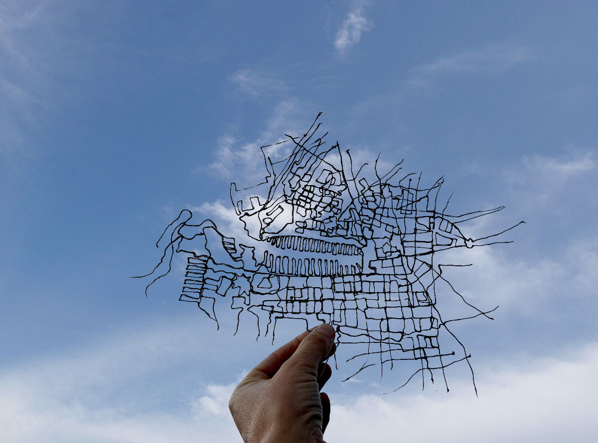
Image © Anna Guilló, 2019
To quote this article: Cristofol, Jean and Guilló, Anna, "Alternative cartographies" published on July, 10th, 2020, antiAtlas #4 | 2020, online, URL : www.antiatlas.net/04-alternative-cartographies, last consultation on Date.
1 The Manif.app application developed by Antoine Schmitt in collaboration with Hortense Gauthier allows anyone with a smartphone or a computer to take part in the May Day demonstration through a simple device – using an avatar, a rallying cry/slogan, giving a specific location on a world map. It might have looked like a last resort solution for all these people who could not take to the streets this year on the Labour Day because of the COVID 19 health crisis. Yet, this device proved to be highly effective and – even though its design could seem a bit basic – greatly poetic. "You are anonymous. But you are there": this is what the artists write at the end of the text presenting Manif.App, a sentence which has been wildly confirmed given the immense number of manifestations that appeared on the world map on May 1st, followed with a smaller number ever since but every day: all kinds of claims from the most serious to the funniest, but all showing a sure sign of revolt.
next...
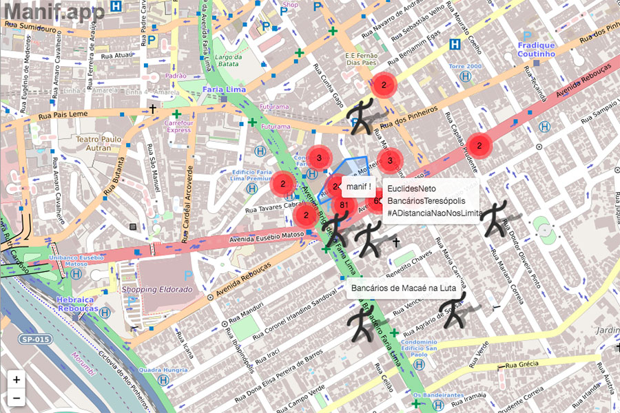
Manif.app, Antoine Schmitt with the collaboration of Hortense Gauthier, screen capture: https://manif.app/
2 Cartography, as we know, has attempted to represent the earth, the sky and the seas, mainly led by practical and/or ideological reasons. Although it is generally associated with scientific objectivity, somehow suggesting a « natural » outlook, the "overlooking" map is of course a matter of construction as much as a choice of representation; it is the artefact through which the imaginary gives shape to territories. It defines the boundaries of a reality which comes foremost from the point of view of cartographers. But this issue of the antiAtlas Journal is not the umpteenth one that would take cartography as its subject; its authors neither think from maps nor they write on them. After having been unfolded and declined ad infinitum, the map is no longer here only seen as an object, tool, practice or method, but rather as an apparatus to support a process of thought on the question of migratory movements and exiles which must today be at the heart of our concerns. To think of the map as an apparatus is, obviously, to resituate it as an expression, a component of a theoretical, technological and operational process; it amounts to consider it not only as the second representation of a previously given reality, but as a structure that produces its own purpose, articulates intentions and interests, generates and shapes behaviors. This is exactly the object of critical cartography; in their contribution "Beware of maps, not migrants!", Françoise Bahoken and Nicolas Lambert’s article uses the form of an exercise, training us to challenge the supposed impartiality of maps.
To think of the map as an apparatus (...) amounts to consider it not only as the second representation of a previously given reality, but as a structure that produces its own purpose.
Already in the 1950s, walking artists were the first to create figurations of their byways, thus inviting people to think and experiment differently map and space. They build narratives that do not necessarily relate to subjective cartography, which would critically rethink the planning of the city; but they also question the construction of the institutions and the images of the city by characters who have become historical figures and monuments that have become national heritage but whose past often reveals inglorious hours. Thus, in a contemporary approach to cartography, as a mode of figuration of geo-political space, it is important to differentiate what is produced through the dynamic term mapping as opposed to the term cartography, indicating a more static form.
next...
3 Karen O'Rourke has highlighted this distinction more than once in her texts, and she actually made a practical application of it when she decided to immerse herself for several months in a suburb of Houston. There, a community of African American artists had managed to take again possession of 22 shotguns since the early 1990s. A shotgun is a narrow and rectangular house with a succession of rooms, each of them separated by a front and a back door. Built of wood on stilts, it probably originated from the Yoruba houses whose inhabitants were partly deported to the USA as slaves and who, once free, took over this cheap kind of construction. Beyond cartographic representations, a complex field unfolds, an objective spatial tessitura where a set of more or less combined or articulated systems – satellite imagery, spatial data capture, geolocation, mobility technologies – interlace. In Karen O'Rourke's meticulous investigation, this spatial tessitura is inseparable from complex cartographic practices immersed in everyday life, which deploy new forms of individuals’ setting/folding in space and contribute to structuring their relationships.
next...
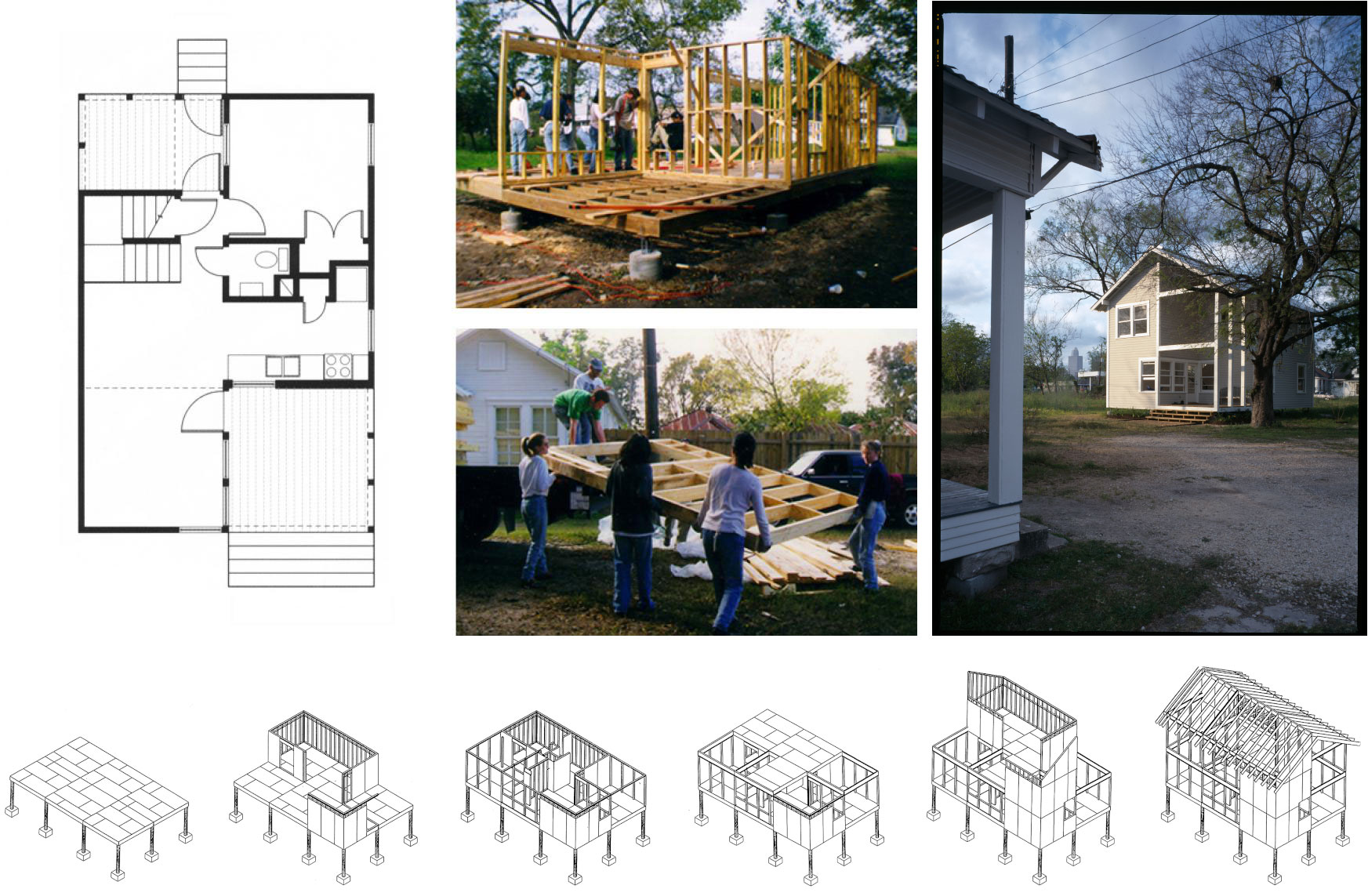
Excerpt from Karen O'Rourke's article: Six Square House (1997-1999) was the first prototype of the Rice Building Workshop for the HRP. Top left: plan. Middle: panel assembly. Right: The house completed in 1999. Below: Axonometric drawings show the modular construction. Images: RBW/Construct and Live/Work website, 2006:58,60,61.
4 These relationships are also at the heart of Flore Grassiot and Laila Hida's action-research project which explores the complex world of false guides in the medina of Marrakech. Through a collaborative work based on collectively thought-out and carried out patterns, they try to thwart the stereotypes linked to orientalist representations. They also attempt to challenge negative and erroneous representations that the inhabitants and the representatives of local tourist institutions make of these so-called illegal practices. Through this ongoing project, new uses of space have now emerged, where practices, knowledge and action plans are being combined to transform and shift the way we think about what we call "territory".
next...
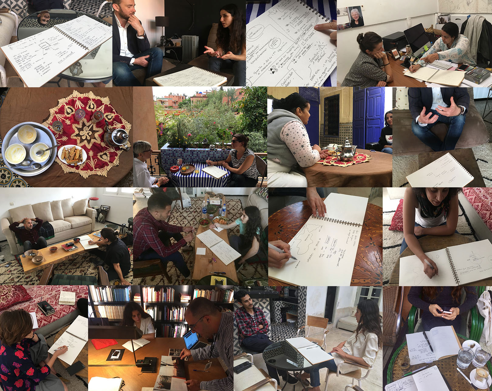
The False Guides. From February to December 2019, sessions of interviews recorded, annotated and mapped on notebooks. Photographs: Laila Hida and Flore Grassiot. Editing: Laila Hida.
5But the territory is not some sort of a large workshop that some artists have glorified and poeticized like the first land artists who set out and drew lines in the desert. It is also this bitter desert where we find the remains of thousands of bodies: those of women and men who tried to cross the border between Mexico and the United States. It is from this very place that Tara Plath reflects on what she calls the "deterrent imperative" developed by the Border Patrol's Prevention through Deterrence. The US border police wildly spread a map composed of a dense forest of small dots, each representing a "dead person" in the desert. It is not a secondary representation based on established facts, but it rather becomes a producer of national sovereignty in a general strategy of deterrence. The spaces of deterrence that constitute these maps somehow "produce" death in order to legitimize border policing through fear: the device would seem almost coarse if it were not so dreadfully effective. Punctuated by a long interview filmed with two forensic scientists who patiently try to give an identity to each bone found in this desert, the article tries to oppose the cold and untrue mapping of the police with the singularity of the disappeared.
next...
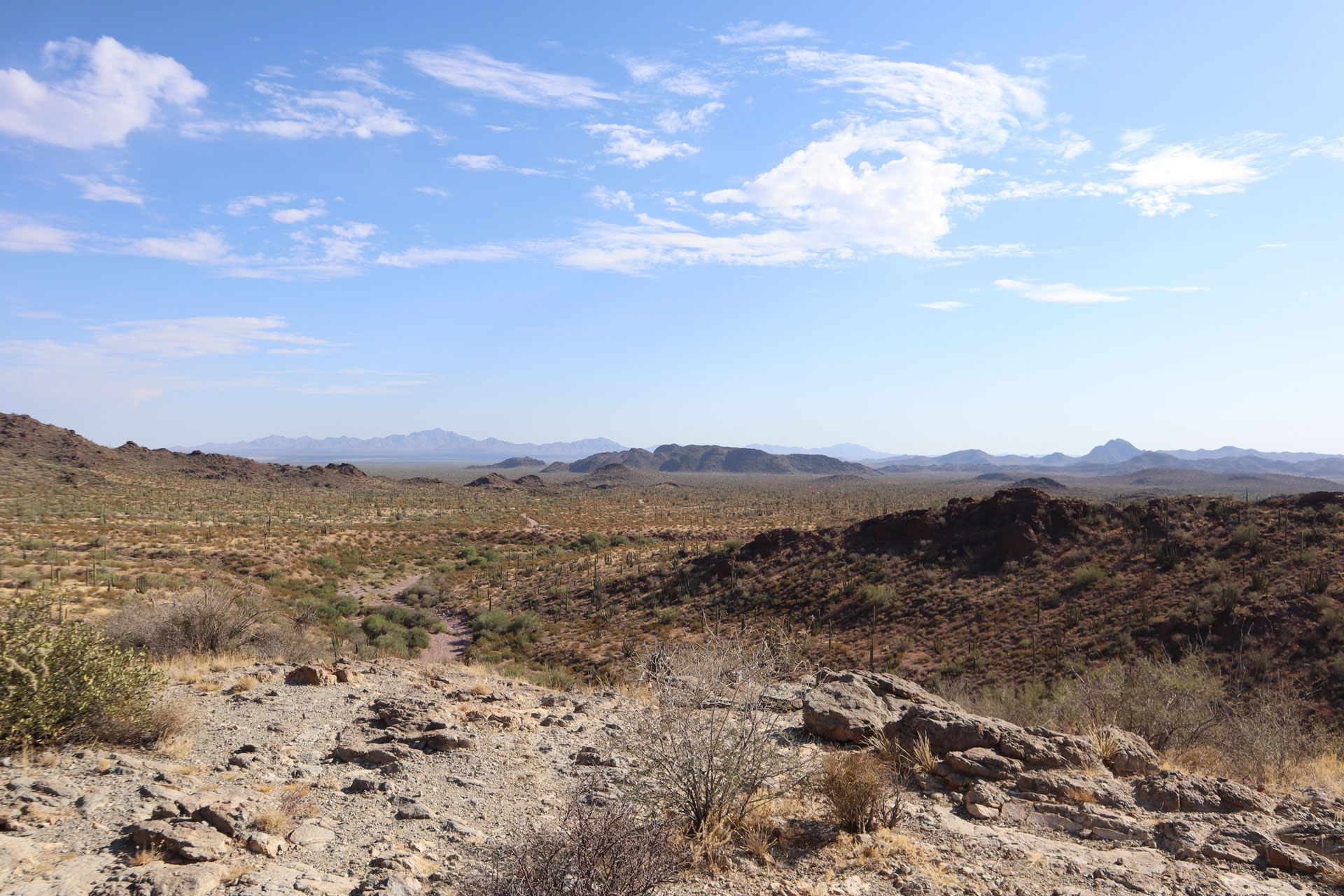
The horizon of the Sonoran Desert in southern Arizona, taken from the Organ Pipe Cactus Monument. Photograph Tara Plath, July 2019.
6Because cartography has been the tool for "stabilizing" the world, the nation states and their borders, its study today includes new systems of visibility, such as the diagrams and drawings produced not only by geographers, social scientists and artists' collectives, but also by the ordinary people, actors of a new inscription of the world on the world. The term "map" then becomes, perhaps by improper extension, the locus of a practice for those who wish to approach the world through a new point of view that can no longer be ignored: that of images in migration and, more generally, what Arjun Appadurai calls ethnoscapes, models that are essential for understanding the nature of the relations that people still maintain with their own culture as they move constantly, as they experience a never ending transit. Despite the diversity of the soils they tread on, the map is in them.
Since its beginnings, the antiAtlas of Borders collective has tried to explore singular forms of research and associations of thoughts that the academic world has often wanted to compartmentalize. In this issue of the antiAtlas Journal, we broaden a little further the scope of our collaborations and publish an article by Sara Bédard-Goulet on Jean Échenoz’s novels whose cartographic devices here enter in a fecund and clever dialogue with the wall drawings of Quebec artist Josée Dubeau. Like Sylvie Fabre, a character in L'Occupation des sols, whose image painted on a wall of a Parisian building is all that remains of the charred wife and mother, the contributions in this issue, which take us successively from the Medina of Marrakech to the Mexican border via the suburbs of Houston, draw a map that tries to fight against personal erasure, "braving wind erosion with all the force of its two dimensions". Thereby maps carry us since they help us investigate, since they give rise to alternative forms of understanding and contest, since they bear a creative force whose devices we must learn to understand in order not to be fooled.
next...
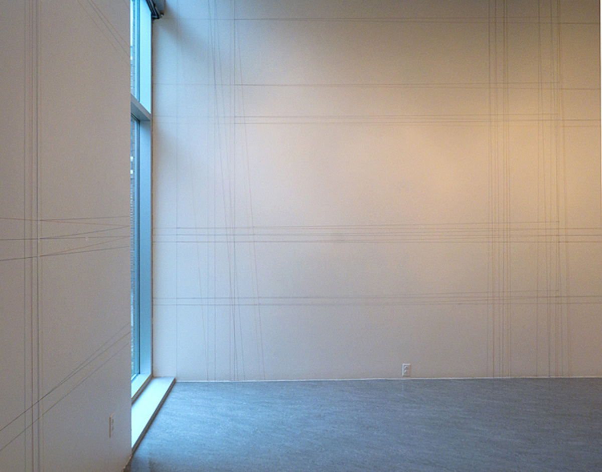
Josée Dubeau, Vanishing Lines (detail), 2013. Mural drawing with coloured threads, variable dimensions, Centre Vaste et Vague.
7Consequently the authors of this issue apprehend the map far beyond representation, as an element and a moment of a device that hinges on the practices, intentions and strategies of different actors (individuals, communities, institutions) in contexts that are always specific. Instead of considering it in the frame of a face to face relation with the world and as an external and fixed image of it, they approach it as an interiority or more precisely an inter-position that is constantly modified, reconstructed, re-imagined, re-situated in a movement, an exchange, a balance of power, a writing process or an artistic process. The map is no longer one but many, it is no longer at a standstill but in motion, no longer a whole but just an interesting element of an ongoing process. It undoubtedly grasps within itself a part of reality, but it is also an inseparable part of that reality. Like some performative utterances, the cartographic device is endowed with a constructive ability/role, and it contains and implements here not only a reflection on the territory but an action in and with the territory.
Jean Cristofol and Anna Guilló
next...
Notes
1. See in particular Walking and Mapping. Artists as Cartographers, MIT Press, coll. « Leonardo », 2013
back to the top of article...
https://www.antiatlas-journal.net/pdf/antiatlas-journal-04-Cristofol-Guillo-alternative-cartographies.pdf